 |
A synthesis of challenges and opportunities
|
| |
A synthesis of challenges and opportunities
|
Julia S. Becker, GNS Science, P.O. Box 30368, Lower Hutt,
New Zealand. Email: j.becker@gns.cri.nz
Wendy S.A. Saunders, GNS Science, P.O. Box 30368, Lower Hutt,
New Zealand.
Clare M. Robertson, School of People, Environment and Planning,
Massey University, Private Bag 11222, Palmerston North, New Zealand.
Graham S. Leonard, GNS Science, P.O. Box 30368, Lower Hutt,
New Zealand.
David M. Johnston, GNS Science, P.O. Box 30368, Lower Hutt,
New Zealand; Joint Centre for Disaster Research, Massey University, School
of Psychology, P.O. Box 756, Wellington, New Zealand.
Julia S. Becker
|
Clare M. RobertsonSchool of People,
Environment and Planning, |
David M. Johnston Joint Centre for Disaster Research, |
In the North Island of New Zealand a number of active volcanoes exist that could reawaken or erupt at any time. The location of urban areas within and near these volcanic areas constitutes a significant peril. Given the close proximity of settlements to active volcanoes, it is essential that communities and governing authorities understand the nature of volcanic hazards and make plans for mitigating the associated risk. Mitigation can occur in a variety of ways including employing structural measures (e.g., by employing engineering solutions), emergency management processes, or land use planning. Currently land use planning is an underutilised approach for mitigating volcanic risk. The purpose of this paper is to provide an overview of the hazards posed by New Zealand’s volcanic landscape, and to highlight the important role that land use planning can play in reducing volcanic risk. New Zealand and international case studies are presented and the paper concludes with a synthesis of challenges and opportunities for reducing volcanic hazard risk through land use planning.
The New Zealand landmass straddles a major plate boundary, with the Australian Plate located to the east and the Pacific Plate to the west. This plate boundary is active, with the Pacific Plate subducting the Australian Plate in the north, the plates moving parallel in a strike-slip direction along most of the Southern Alps, and the Australian Plate subducting the Pacific Plate in the south. In addition, plate motion is causing rifting in the North Island around the Bay of Plenty area. Consequently New Zealand is subject to a variety of geological hazards including earthquakes, volcanoes, landsliding and tsunamis. In addition, the country also experiences severe weather events, flooding and coastal erosion.
The North Island of New Zealand is subject to a variety of volcanic processes from six active volcanic centres located within a zone known as the Taupo Volcanic Zone (TVZ), a line of volcanoes that runs from Ruapehu through to White Island (see Figure 1). The main active volcanoes and volcanic centres in this zone include: the mainly rhyolitic volcanic centres of Okataina and Taupo; and the andesitic-dacitic composite cones of White Island, Ruapehu, Ngauruhoe and Tongariro (Leonard et al., 2007). In addition to the TVZ, active volcanoes can also be found at several other locations in the North Island and offshore, including the basaltic volcanic fields of Auckland and Northland Regions, rhyolitic Mayor Island and the andesitic cone of Mt Taranaki near New Plymouth city (Leonard et al., 2007). In the sea to the north east of New Zealand lie the Kermadec volcanoes, of which Raoul Island sits above the ocean surface.
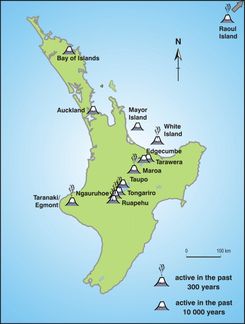
Figure 1. Location of active volcanoes in New Zealand (Figure: GNS Science)
The nature and timing of eruptions from the aforementioned volcanoes vary depending on the volcano in question. In general, smaller eruptions occur more frequently (e.g., small geothermal eruptions are likely to occur every few years; small ash eruptions at the cone volcanoes every decade or so), while larger rhyolite eruptions have a lower frequency of occurring (at least every few millennia to tens to hundreds of thousands of years) (Wilson & Leonard, 2008). This range in eruption sizes and occurrences can make planning for volcanic activity difficult. However, under the environmental planning legislation in New Zealand [notably the Resource Management Act 1991 with amendments (RMA)], volcanic hazards are included as a natural hazard which must be considered in planning. This paper provides a succinct overview of the range of volcanic hazards that exist and need to be planned for in New Zealand. New Zealand and international case studies are presented to highlight opportunities for reducing volcanic risk through land use planning.
Given the significant number of active volcanoes that exist in New Zealand, there is potential for many urban and rural areas to be affected by a volcanic event. This section provides an overview of volcanic hazards in New Zealand.
Ash Falls
Ash falls are the most likely volcanic hazard to be experienced by
communities in New Zealand. In an eruption, ash will be carried by the wind from
an erupting vent and deposited according to the wind direction on that day. Thick
ash (e.g., between 100-300 mm) can cause buildings to collapse and vegetation
to be buried (Blong & McKee, 1995). Thinner layers of ash can impact upon
water and waste water (Stewart et al., 2006), machinery, buildings, agriculture,
public health, transportation, communication and electricity generation (US Geological
Survey and partners, 2009). Wet ash can cause buildings and other structures
to collapse sooner than those covered in dry ash due to the additional weight.
Pyroclastic Flows and Surges
Pyroclastic flows and surges are very destructive clouds made up of
gas and volcanic particles. They move at such high velocity (up to 100-200 km/hr)
that they can envelop and destroy everything in their paths (Nakada, 2000). Some
New Zealand settlements are located within pyroclastic flow or surge hazard
areas, for example, some development around Lake Tarawera and Lake Okareka
is located within a mapped pyroclastic flow zone (Johnston & Nairn, 1993;
Scott & Nairn, 1998).
Debris Avalanches
A debris avalanche is the sudden catastrophic collapse of an unstable flank
of a volcano (Ui et al., 2000). Avalanched material follows valleys as it moves
down the side of a volcano under the force of gravity. A debris avalanche is
very destructive and can destroy everything in its path. Steeper sided volcanoes
such as Taranaki have the potential to create significant debris avalanches.
Lava Flows
Lava flows tend to be one of the more benign hazards in terms of life-safety
but still can cause a great deal of damage. Lava flows move relatively slowly
and cover limited areas, so the risk to life from lava is not high (Peterson & Tilling,
2000). Lava flows will cover and destroy structures that cannot be moved away
from the path of the flow, and can start destructive urban and forest fires
(Thorarinsson, 1979). Lava flows are likely to be most disruptive where the
volcano is located within or near to a settlement (e.g., lava flows would be
very disruptive if they occurred within the confines of the city of Auckland).
Lahars
Lahars are often also known around the world as mudflows. Lahars can
be produced in a number of different ways, including snow or ice melted by erupted
ash or lava; an eruption through a crater lake or emptying of a crater lake to
cause water and mud to flow down the side of a volcano; heavy rain falling
on to unconsolidated ash; and the movement of a pyroclastic flow or debris
avalanche into a river or lake (Rodolfo, 2000). Lahars can be very destructive,
and may damage or destroy buildings, bridges, other structures, vegetation,
people and animals (Baxter, 1990; Johnston & Houghton, 1995). In New Zealand,
the most frequently occurring historic lahars have been associated with small
eruptive events, for example, 1995 Ruapehu eruptions (Cronin et al., 1997)
or dam-breach lahars, for example, Ruapehu Crater Lake in March 2007, 1975,
and 1953 (Manville et al., 2007). The Ruapehu lahars have affected relatively
restricted geographical areas, containing limited development and infrastructure.
However, if a large eruption was to occur (e.g., a rhyolitic eruption from
Okataina Volcanic Centre) there is potential for widespread lahar activity
(from the mobilisation of ash) that could continue up to decades after an eruption.
Geothermal Eruptions
Eruptions from geothermal fields are generally small (but occur frequently)
so damage will only occur up to a few hundred metres from the vent. Geothermal
fields also pose gas and geothermal fluid hazards (Hansell et al., 2006). A
number of New Zealand settlements are built on sites that are subject to geothermal
eruptions, (e.g., Rotorua City), and therefore such hazards need to be considered
in planning.
Tsunamis and Seiches
Tsunamis and seiches are secondary hazards that can be generated by
volcanic eruptions and associated landside activity (Begét, 2000; Latter,
1982). Low-lying land on the edge of coastal areas, lakes and nearby rivers can
be flooded by volcanic generated tsunamis and seiches. In New Zealand seiches
could occur on lakes with active volcanic vents (e.g., Taupo, Okataina), while
a tsunami may be a possibility if, for example, a new vent were to emerge in
the harbours around Auckland.
Flooding
Following a volcanic eruption, the deposition of volcanic sediment in valleys
may disrupt normal stream or river flows. Channel aggradation, and the increased
lateral migration of channels and bank erosion may occur. These conditions
can cause damage to structures and exacerbate normal seasonal flooding (Pierson,
1989). Stream blockages can create temporary lakes (Blong, 1996). Erupted volcanic
material can also block an outlet to an existing lake or river causing a body
of water to build up behind a dam. When this dam breaches due to erosion, or
is overtopped, large scale catastrophic flooding can occur.
Other Volcanic Hazards
Other hazards also exist but are not discussed in detail in this paper as they
are difficult to plan at a land use level. These include ballistic fall, volcanic
earthquakes, volcanic gases, electrical discharges and other secondary hazards
such as famine.
For volcanic hazard management strategies to be effective, the hazard and risk posed by volcanoes need to be well understood. This section outlines ways in which a better understanding can be gained about volcanic hazards and risk, and how risk might be addressed. In particular it covers the value of mapping volcanic hazards, the role of monitoring volcanoes, the role of warning systems and the potential role of land use planning.
Definitions
‘Risk’ is often misunderstood and confused with ‘hazard.’ A
hazard is a potentially dangerous event, such as a lava flow, a pyroclastic
flow, or ash fall having the potential to affect society. The risk is the likelihood of
a person or a property being harmed or damaged by such an event. Volcanic risk
will depend on a number of facets, including the timescale in question (e.g.,
time spent in the hazardous zone), the location of people and their assets,
their social vulnerability and the current state of the volcano.
Hazard Maps
Hazard maps are essential for understanding what locations are subject
to volcanic hazards and the risk posed. Mapping both the physical peril and the
exposure and vulnerability of people to volcanic hazards can help guide decisions
about where to locate critical infrastructure and human settlement (e.g., avoid
development in high risk areas) and other mitigation measures that might be
appropriate. Hazard mapping has been undertaken in Hawaii, for example, with
the intention of guiding land use planning decisions. But actual use of hazard
maps to inform land use decisions has been limited (Kauahikaua & Trusdell,
2005; US Geological Survey, 2004). In New Zealand many volcanic hazards have
been identified and mapped, including volcanic centres at Taranaki (Figure
2), Ruapehu, and Taupo, and the Okataina Volcanic Centre, however, as per the
Hawaii example, there has been little use made of these maps for land use planning
purposes.
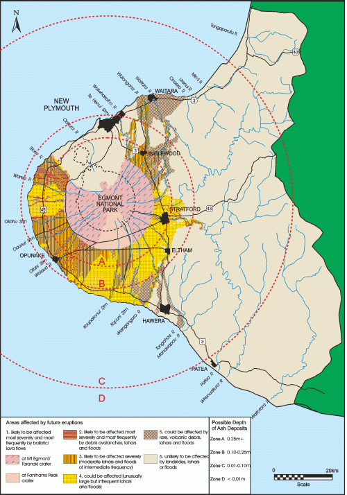
Figure 2. An example of a volcanic hazard map for Mount Taranaki as used in the Taranaki Civil Defence Emergency Management Group Volcanic Strategy (Taranaki Regional Council, 2004).
Most volcanic hazard maps tend to be drawn at a regional scale (e.g., the Okataina hazard map is 1:100,000) rather than at a scale appropriate for land use planning (such as 1:10,000) (Saunders & Glassey, 2007). Some smaller scale volcanic hazard overlays have been made for some areas, for example, Auckland City (Olsen & Williams, 2005), but these have been designed for specific projects on hazard assessment and contingency planning and not for land use planning purposes. For the Ruapehu ski areas, schematic evacuation maps have been developed to aid understanding of what to do if a lahar warning is issued (Leonard et al., 2008). Many volcanic hazard maps are based on specific past or projected scenarios rather than the full range of probabilistic hazards posed. Maps should represent the full range of probable hazards that can be expected to an agreed probability – i.e., all potential future scenarios, not just those known from the past. Individual scenarios may not show the full risk of volcanic hazards to communities as they only focus on the specific impacts of the scenario itself. Maps showing overall probabilistic hazard, verified to make sure they encompass known past scenarios, allow a better understanding of the actual risks posed to different locations, as risk is aggregated for all potential scenarios. Probabilistic hazard maps therefore provide a better basis for planning mitigation strategies. It is also imperative to map social vulnerability to volcanic hazards to ensure that risk reduction and preparedness measures are targeted appropriately.
Traditional Knowledge
Traditional knowledge can contribute to understanding volcanic risk,
especially when the geological or written history of a volcano is limited (Cronin
et al., 2004). Indigenous communities often have their own understanding and
ways of articulating a volcano’s processes. They may also have traditional
systems of land use planning and emergency management practices. Opportunities
exist to better utilise traditional knowledge and practices to address volcanic
risk.
Monitoring of Volcanic Hazards
New Zealand’s volcanoes are continually monitored as part of the national
GeoNet monitoring project. Volcanoes are monitored so that changes in volcanoes’ behaviour
can be detected. These changes give scientists indications of what a volcano
may do in future, and thus what hazards might or might not be anticipated.
Volcano monitoring includes visual observation, detecting earthquakes and tremor
with seismographs, analysing gas and water chemistry, and gauging ground deformation
(GeoNet, 2009).
Warning Systems for Volcanic Hazards
A Volcano Alert Level numbering system is used to reflect the current
status of any given volcano in New Zealand. The system is numbered from 0-5 (none
or low activity through to full eruption) and scientists allocate the appropriate
number depending on activity levels. Indicators used to describe levels differ
depending on whether the volcano is frequently active (i.e., Ruapehu, Tongariro-Ngauruhoe,
White Island, Kermadec Islands) or re-awakening (i.e., Auckland, Mayor Island,
Northland, Okataina, Rotorua, Taranaki, Tarawera, Taupo). The alert level system
is a practical way of showing local, regional and central government authorities,
the aviation and tourism industries, media and the public if there are any
changes in a volcano’s behaviour. Responding agencies in New Zealand
are notified whenever the alert level changes, and they can use this information
to determine the type and scope of their response (GeoNet, 2009).
Other warning systems for volcanic activity exist, in particular for lahar hazards. Internationally, these systems tend to focus on the technology of monitoring and alert generation, rather than any specific measures to promote effective response to warnings (Basher, 2006). At Ruapehu in Tongariro National Park, for example, there are two lahar warning systems, namely the Eastern Ruapehu Lahar Alarm & Warning System (ERLAWS) and the Eruption Detection System (EDS). The ERLAWS system was put in place to monitor the natural dam breach of the Crater Lake that occurred in 2007, but remains in place for future lahars in the Whangaehu River channel. When ERLAWS is triggered by a lahar it automatically alerts emergency responders, who respond according to planned emergency management actions. The EDS monitors eruptions and broadcasts automated lahar warning messages across Whakapapa ski area (Leonard et al., 2008).
To have an effective warning system it is important that not only hardware such as the EDS and ERLAWS is in place, but that human behaviour is also considered so that the public receiving a warning can react appropriately. An effective warning system should ensure that the following components are in place: hardware; planning; cooperation, discussion and communication; education and participation; exercises; research and science advice; and effectiveness evaluation (Leonard et al., 2008).
The role of land use planning in reducing volcanic risk
While New Zealand’s volcanoes are monitored to detect changes in activity,
monitoring, forecasting and warning systems should not be solely relied on
to reduce risk. Even with the best available monitoring, it is not possible
to forecast all eruptions. Generally, larger potential eruptions are easier
to detect as these produce more significant pre-cursory signals, while smaller
eruptions (e.g., ‘blue sky’ eruptions from Mount Ruapehu) are not
as easy to forecast. There will always be some residual risk, even with the
issuance of warnings. Warnings generated for hazards such as lahars may not
reach all of the population at risk, or people may not respond appropriately
on receiving a warning. Land use planning can make a distinctive contribution
to volcanic risk reduction by providing a publicly accountable process that
enables communities to reduce volcanic risk by avoiding or limiting the exposure
of people, critical infrastructure and valuable assets to volcanic hazards.
The planning process facilitates consideration of and action to reconcile contending
public and private interests in development in at-risk areas relative to community
safety and sustainability. Experience from around the world illustrates how
land use planning together with other mitigation measures can help to reduce
volcanic risk.
This section of the paper presents several case studies from the USA, Japan and New Zealand that provide a basis for identifying challenges and opportunities for realising the potential of land use planning to reduce volcanic risk.
Case Study 1: Mt Rainier, Washington State, USA
Mt. Rainier in Pierce County, Washington State, USA, presents significant
challenges for volcanic risk reduction (Johnston et al., 2007). Communities
and undeveloped land situated around the base of the volcano are subject to
a variety of volcanic hazards. In Pierce County, under Title 18E of the ‘County
Code’, development restrictions are in place for areas designated to
be subject to significant volcanic hazards. Volcanic hazards have been mapped
and include lahars, other types of debris flow, pyroclastic flows and lava
flows. These volcanic hazards have been mapped according to different zones
based on the frequency and nature of the hazard (i.e., Lahar Inundation Zone
I, Lahar Inundation Zone II, Lahar Inundation Zone III and Pyroclastic Hazard
Zone) and the travel time of such a hazard reaching an area. Each of the zones
are regulated (Table 1). For all of the Lahar Inundation Zones and the Pyroclastic
Flow Zone, extra development density, essential facilities and hazardous facilities
are prohibited. Special occupancy structures and covered assembly areas are
limited to certain numbers of people in Lahar Inundation Zones I and II, and
are prohibited in Lahar Inundation Zone III and the Pyroclastic Flow Zone
(Pierce County, 2004). The purposes of the regulations are twofold: to keep
development out of areas to prevent damage; and to limit the number of people
in an area to facilitate evacuation (Pers. comm. B. Pierson, Pierce County,
2007).
Table 1. Volcanic Hazard Area Standards used by Pierce County (Pierce County, 2004)
Facility/ |
Case I : Lahar |
Case II : Lahar |
Case III: Lahar |
Pyroclastic Flow |
Bonus Densities (1) |
Not allowed |
Not allowed |
Not allowed |
Not allowed |
Essential Facilities (2) |
Not allowed |
Not allowed |
Not allowed |
Not allowed |
Hazardous Facilities (3) |
Not allowed |
Not allowed |
Not allowed |
Not allowed |
Special Occupancies (4) |
In Travel Time Zone A In Travel Time Zone B In Travel Time Zone C In Travel Time Zone D |
In Travel Time Zone A In Travel Time Zone B In Travel Time Zone C In Travel Time Zone D |
Not allowed |
Not allowed |
Covered Assemblies (5)
|
In Travel Time Zone A In Travel Time Zone B In Travel Time Zone C In Travel Time Zone D |
In Travel Time Zone A In Travel Time Zone B In Travel Time Zone C In Travel Time Zone D |
Not allowed |
Not allowed |
Other Occupancies |
No limitation |
No limitation |
No limitation |
No limitation |
(1) Bonus Density as set forth
in Chapter 18A.35, Development Regulations-Zoning. |
||||
The best of intentions can be thwarted, however, if not all parties within the same geographic area follow the same regulations. The City of Orting, while located within Pierce County, is not subject to the standards outlined by the County and has its own regulations on development. It also has the legal right to acquire land on the boundaries of the city, so that the city can keep growing. Thus, while Orting does have some regulations for flooding, i.e., Title 14, Flood Control (City of Orting, 2008), there are no specific development restrictions for lahars, which may affect the city. Within Orting’s city boundaries, reliance is placed on emergency management measures to remove people from harm’s way.
Case Study 2: Mt Usu, Hokkaido, Japan
Mt Usu, in Hokkaido, Japan, presents particular challenges to nearby
settlements because of the threat of explosive volcanic eruptions. Following
a pyroclastic eruption in 2000, zoning was undertaken around Mt. Usu to ensure
that new development and key facilities would be placed out of the way of the
most destructive volcanic hazards (e.g., pyroclastic flows and ballistic fall)
(Figure 3).
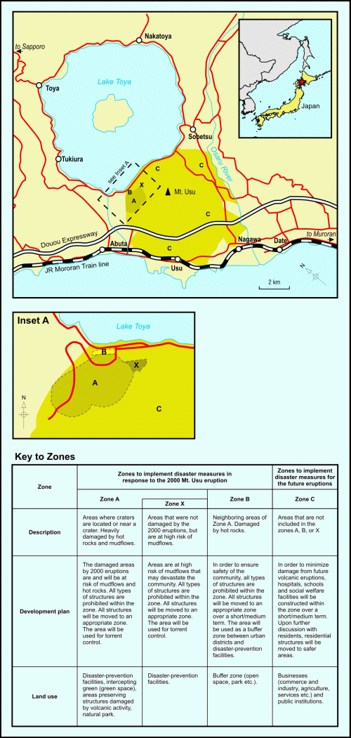
Figure 3. Land use zoning map for areas around Mount Usu (adapted from Nakao, 2005).
Where appropriate, existing buildings, such as the Lake Toya health centre and residential homes, were relocated. These land use planning measures have been combined with engineering solutions (e.g., sabo dams) to mitigate secondary hazards such as lahars; and emergency management readiness and response planning (e.g., warning systems and evacuation) has also been put in place. Additionally, a museum and several recreational parks have been established in areas affected by the 2000 eruption, and are used to educate people about the effects of volcanic hazards (Nakao, 2005; Yamanaka, 2007) (Figure 4). Mt. Usu had erupted previously in 1977, and recommendations were made for reconstruction and re-zoning of residential areas and businesses. Unfortunately the recommendations were not implemented because local agencies were not involved in the project (Nakao, 2005). This lack of action demonstrates the importance of getting the right people involved in devising timely solutions.
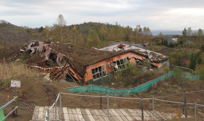
Figure 4. A damaged building in a park created after the Usu eruption to educate people about the effects of volcanic hazards on structures and people (Photo: Julia Becker).
These experiences from the USA and Japan provide valuable insights about the challenges and opportunities for reducing volcanic risks through land use planning that are reinforced by local New Zealand experience.
Case Study 3: Auckland Volcanic Field, New Zealand
Governed by a various local authorities [endnote
1] Auckland
is New Zealand's largest urban area and the centre of New Zealand commerce
and industry, with more than 1.3 million people, approximately a third of the
country's population (Statistics New Zealand, 2007). Within a 20 km radius
there are at least 49 discrete volcanoes (Figure 5), several of which have
erupted in the last 20,000 years (Smith & Allen, 1993).
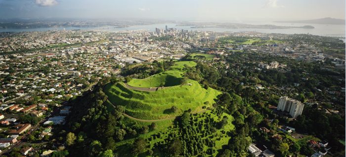
Figure 5. Auckland Volcanic Field in the North Island of New Zealand (Photo: Lloyd Homer)
Past volcanic activity has produced a variety of hazards including pyroclastic surges, ballistic fallout, ash falls and lava flows (Allen & Smith, 1994). Future eruptive activity could occur at any new location, causing potential fatalities and damage to and destruction of structures, businesses, transport, communications, services and livelihoods. The Civil Defence Emergency Management (CDEM) Group Plan for Auckland has ranked volcanic activity as a high priority hazard within the region (Auckland Region Emergency Management Group, 2005). However, while regional and district land use plans acknowledge that there is a volcanic presence, there are no specific land use planning provisions in place to restrict land use or development with respect to volcanic hazards (Kerr et al., 2003). Hazard avoidance through land use planning is not feasible given the population size, and extent of economic and urban development. Moreover, the exact location of future eruptive activity cannot currently be pinpointed, and this may never be possible until magma rises close to the surface during an event. All of these factors make implementing rigid land use planning rules that prevent exposure to volcanic processes virtually impossible. Innovative mitigation measures are therefore required to limit potential impacts and, among other things, ensure that key lifelines have capacity within their systems to continue to provide a satisfactory level of service to the Auckland region if part of their network is affected by volcanic activity. Improvements could be made through urban design measures specifically geared towards reducing volcanic risk, and buildings and infrastructure could be designed to reduce the impacts of ash fall if prolonged volcanic activity became an issue (Figure 6). In addition, pre-planning at a local level should consider aspects of land use planning and emergency management that are likely to be encountered during a volcanic event (e.g., evacuation; ash disposal; welfare issues, etc). Auckland Civil Defence Emergency Management Group and the Auckland Engineering Lifelines Group are currently working on aspects of readiness, response and recovery planning. As an example, in March 2008, Exercise Ruaumoko was held in Auckland to test the scientific input, media reporting, and practical exercises local and national emergency management organisations would need to undertake in the event of a real volcanic eruption in the Auckland area (Phoenix Research, 2008).
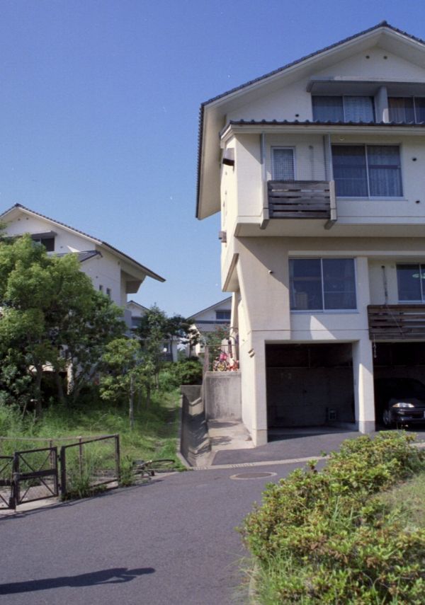
Figure 6. An example of urban design used to mitigate the effects of ash fall in Kagoshima, Japan. The design of the housing includes gutter-free roofs (which have a storm water channel located directly beneath), ash-resistant tiles, heavy-duty rubber window and door seals (to aid air tightness to prevent ash entering houses) and large overhanging roofs over balconies (Photo: David Johnston).
Case Study 4: Taranaki, New Zealand
Data from the 2006 New Zealand census indicates that just over 100,000
people reside within the Taranaki Region, with a significant proportion living
in the main centre of New Plymouth (Statistics New Zealand, 2007). The volcanic
cone of Mt Taranaki dominates the landscape of this region (Figure 7). This
volcano has been active for the last 130,000 years and last erupted approximately
200 years ago. Evidence from previous volcanic eruptions show hazards from
Taranaki include lava flows and lava domes, pyroclastic flows and lateral blasts,
landslides, lahars, volcanic gases and ash falls (Neall & Alloway, 1993).
As indicated in Figure 2, Taranaki’s volcanic hazards have been mapped
to indicate which areas are at risk.
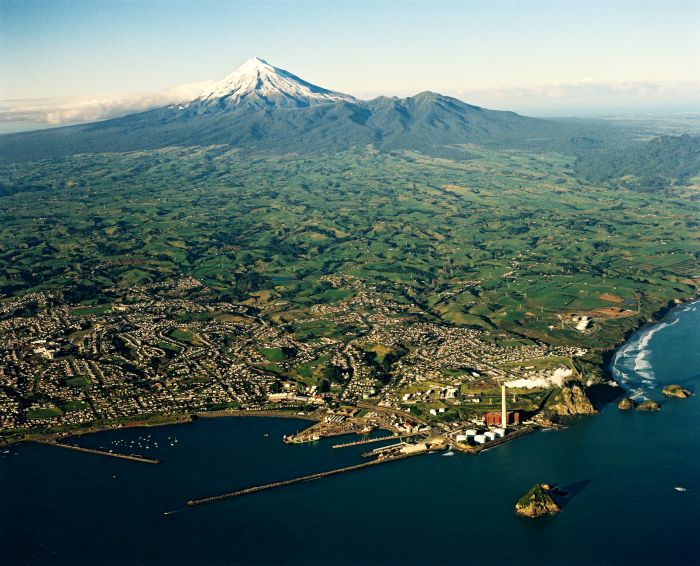
Figure 7. Mount Taranaki in the North Island of New Zealand (Photo: Lloyd Homer)
The Taranaki CDEM Group Plan has identified volcanic activity as a high priority hazard (second in hazard rankings, after first-equal placed public health threat; flooding; and local earthquake) (Taranaki CDEM Group, 2004). The Taranaki Region has few areas of intensive urban development and therefore is a good candidate for implementing more rigorous land use planning measures to exclude future development from at-risk areas. While current plans and policy statements for the region refer to the hazards posed by Mt. Taranaki, and include general hazard mitigation policies which can deal with volcanic hazards, only one authority (New Plymouth District) has specific policies or methods for dealing with volcanic hazards through proactive land use planning. The policies and methods in New Plymouth District Plan are (New Plymouth District Council, 2007):
While New Plymouth District Council has included planning for volcanic hazards into its land use functions, there are potentially still ways in which volcanic risk can be reduced. Given that development in the region is at a relatively low level, it is possible that restrictions on development in certain areas (e.g., in lahar paths) or requirements for lower density housing in volcanic hazard areas could be added as part of the district plan. It is also important to improve public awareness and understanding about the volcanic hazards and associated risk so that people are able to participate in making informed decisions about future land use in the region.
Case Study 5: Okataina Volcanic Centre, New Zealand
The Okataina Volcanic Centre (OVC) is located in the Bay of Plenty
between the settlements of Rotorua city and Kawerau township. Scattered small
settlements exist across this area. The OVC consists of a series of vents from
which magma has erupted (Nairn, 1991). Prehistorically, the OVC has undergone
some very large and explosive eruptions, which caused pyroclastic flows and deposited
large amounts of ash and pumice over the Bay of Plenty (Nairn, 1991). More
recently, in 1886, Mount Tarawera underwent a short but explosive basaltic
eruption, depositing scoria and mud across the Bay of Plenty and blocking the
outlet to Lake Tarawera, which subsequently caused a dam-break flood that flowed
through the Kawerau area in November 1904 (Nairn, 1991; 2002). Hazard maps
(Figure 8) and scenarios have been developed for the OVC (Johnston & Nairn,
1993; Scott & Nairn, 1998) and it is noted that a number of smaller settlements
are located within destructive volcanic hazard areas (e.g., Lake Okareka, Lake
Tarawera). Hazards expected from OVC include ash fall, pyroclastic flows, lava
flows, hydrothermal eruptions, volcanic gases, lahars and floods and volcanic
earthquakes. The types of hazards expected at OVC can be compared with those
experienced during and after the 1991 Pinatubo eruption in the Philippines
(Manville et al., 2000).
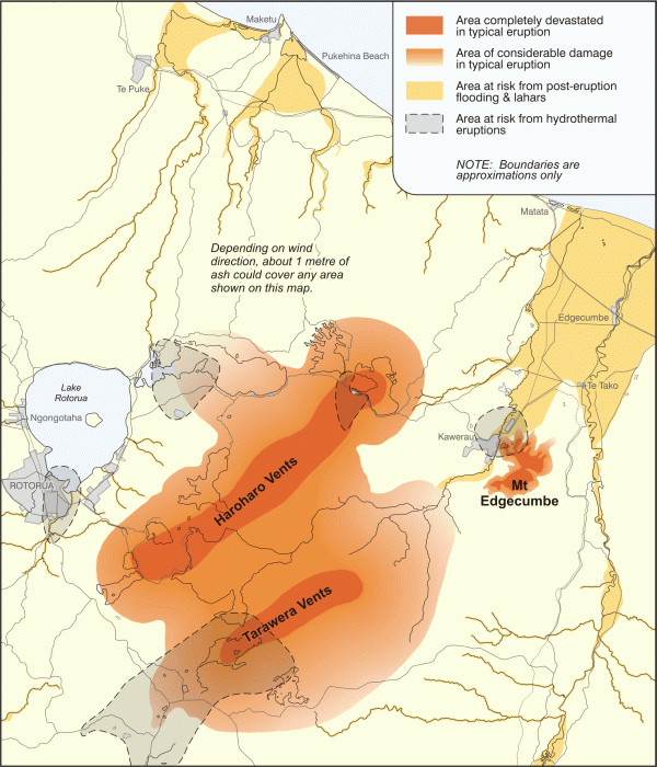
Figure 8. Volcanic hazard map of the Okataina Volcanic Centre (in Nairn, 2002 and adapted from Scott & Nairn, 1998).
The Bay of Plenty CDEM Group Plan rates volcanic activity as a high priority hazard, and outlines current and possible future hazard management mechanisms for volcanic activity (Bay of Plenty CDEM Group, 2005). Neither current nor future mechanisms include explicit land use planning measures but volcanic hazards are addressed (in part) as an issue within the Rotorua District Plan. Objectives and policies within the Rotorua District Plan (Parts 1-19) indicate the need for sound emergency management and land use planning practices. However, there are no volcano-specific methods to apply the objectives and policies. Current methods are hazards-generic. Volcanic hazards are not explicitly marked on planning maps. The plan acknowledges that planning for volcanic hazards is difficult as the problem is large scale and widespread, and states that “information gathered to date on volcanic hazards in the Rotorua District has not pointed to any areas in demand for dense settlement that are at particular risk from more localised effects of volcanic activity” (Rotorua District Council, 1996). Part 20 of the Rotorua District Plan specifically relates to the ‘Lakes A Zone’, an area of lakes in the Rotorua District that incorporates the OVC and has the largest volcanic risk. The focus of planning regulations has been to ensure that the natural and cultural environment of the lake is maintained, however the regulations have the added benefit of keeping numbers of people residing in the volcanic hazard area low. Part 20 of the plan states: “There is a wide range of possible natural hazards and some created hazards that constrain development. The lakes area has a significantly large number of fault lines, the avoidance of which by development, would be impossible. As such, Council’s approach is to keep development at a relatively low density, to apply the provisions of the Building Act 1991 [endnote 2] and implement evacuation procedures rather than prohibit further development in the area. It is not considered practical to avoid the effects of earthquake and volcanic eruptions other than timely evacuation” (Rotorua District Council, 2005). As the lakes are considered to be a great natural asset, development around the lake is required to be of low impact, low density and confined in its spread for visual amenity reasons. Structure plans have been developed to guide any development over future years. In some areas around the lakes, development is prohibited altogether.
Case study 6: Tongariro and Egmont National Parks, New Zealand
The establishment of national parks and the associated restrictions
on human settlements has virtually eliminated volcanic risk in the vicinity of
several active volcanoes in New Zealand. Tongariro National Park was established
in 1886 around the volcanoes of Tongariro, Ngauruhoe and Ruapehu, and Egmont
National Park was established in 1900 around Mount Taranaki. Any development
within the confines of the national parks is restricted and limited. This has
reduced the risks to people from volcanic activity, as the parks are used primarily
for recreational and scientific purposes, reducing the duration of time that
people spend on the mountains and limiting the facilities and infrastructure
that could be affected by an event. The parks were established for conservation,
cultural and aesthetic reasons but this land use planning decision has also
reduced volcanic risk (Becker et al., 2008). A similar outcome was achieved
after Mount St. Helens, Washington State, USA, erupted in 1980 and National
Forest land was procured for a national monument to ensure that future use
of the area was restricted to recreational purposes. This land use planning
has been combined with urban design and emergency management planning measures
to mitigate residual risk (Frenzen, 2007; US Geological Survey 2008).
Residual risk from volcanic activity remains for users (e.g., trampers, skiers, and scientists) within the New Zealand national parks. At Ruapehu this risk is partly mitigated through the ERLAWS and EDS warning systems, staff training, engagement strategies with staff and public, and physical mitigation measures (Leonard et al., 2008). Physical mitigation measures implemented in the past include:
Despite the few measures described in the case studies, there is little comprehensive land use planning for reducing volcanic risk in New Zealand. Kerr et al. (2003) reviewed 17 North Island regional and district plans to assess if and how the plans included land use planning policy measures for managing volcanic risk. While all of the 17 plans included policies that addressed natural hazard risk, none of the plans supported these policies with rules restricting land use and development specifically for volcanic activity. Some very brief volcano land use planning advice does exist in the Ministry for the Environment’s Natural Hazard Guidance Note (Ministry for the Environment, 2008), however this guideline is very recent and it would appear that suggestions have not yet been applied by local authorities. Additionally there appear to be few examples of land use planning for volcanoes overseas, and little or no published international planning guidance.
The limited application of land use planning for reducing volcanic risk is due in part to a number of barriers, which include: the sporadic nature of volcanic activity; uncertainty over the timing, magnitude and impact of potential eruptions; limited guidance on volcanic hazards planning; the difficulties of incorporating information about volcanic hazards into land use plans; the variable quality of local authority plans; problems with giving effect to plan intentions; the lack of integration between the emergency management and land use planning professions; land ownership; and the development potential of land subject to volcanic risk which often overshadows concerns about any hazards present. Many of these challenges are also faced in seeking to reduce natural hazard risks in general.
In terms of information, a recent study in the Taranaki Region of New Zealand by Robertson (2007) found that scientific information about volcanic hazards was not being incorporated effectively into land use planning. Four main barriers were found, namely a: (i) focus by planners, decision-makers and emergency management professionals on mitigation and recovery planning rather than proactive avoidance measures; (ii) focus by scientists on the geo-physical processes and probability of hazards rather than understanding the human dimensions and social implications of hazards that is central to volcanic risk reduction; (iii) poor understanding of scientific information by the general public, planners and decision-makers at a district council level; and (iv) the true risk posed by volcanic hazards not being appreciated or ignored and therefore not proactively addressed at district council level.
This section outlines improvements that could be made to ensure land use planning for volcanic risks is more readily applied. While there is little that can be done to change the nature of volcanism, other facets can be addressed including ensuring better incorporation of information, improving plan quality and implementation of plans, and ensuring better integration between the land use planning and emergency management sectors when addressing volcanic risk.
Incorporation of hazard and vulnerability information into land use
planning
To successfully implement land use planning for volcanic hazards, it is essential
that information related to volcanic hazards and risk is proactively incorporated
into land use planning processes and documents. This includes scientific information
on volcanic hazards (including hazard maps), as well as social aspects of planning
for hazards including risk, vulnerability and resilience. As an example, scientific
information about volcanic hazards could be mapped onto planning-scale maps,
similar to how New Plymouth District has mapped the lahar hazard (1:30,000).
This could be compared with available information on vulnerability and resilience.
Finnis et al., (submitted) provides examples of how vulnerability and resilience
to volcanic hazards can be spatially measured. Where possible, any local authority
policies, objectives and rules for development should reflect the hazards shown
on planning maps, and associated vulnerability and resilience information.
Consideration of the probability of an event occurring could also be undertaken,
with authorities setting policies that reflect a particular probability.
To ensure that information about volcanic hazards and risk is accurately understood and effectively incorporated into land use plans and policies, planners need to work collaboratively with scientists, local authority staff and other stakeholders (Becker et al., 2005). Community input is also essential and the public should be engaged in planning for hazards in a participatory manner. Communities should be enabled to discuss problems relating to natural hazards and be involved in devising solutions for reducing risk.
Improving plan quality and implementation of plans
A key to ensuring volcanic hazards are accounted for in a land use
context is to ensure they are adequately addressed within policy statements and
plans. As stated earlier, New Zealand land use plans and policy statements currently
have very little volcanic hazard content. This is possibly due to the fact
that only limited guidance is available to planners to show them what options
are available. Plan quality could be improved by the development of nationally
applicable best practice guidance that specifically targets land use planning
for volcanic risk reduction. Such guidance could provide planners with advice
on the role of land use planning in reducing volcanic risk and how to account
for volcanic hazards where necessary. To enable such guidance to be introduced
into plans and policy statements, and implemented on the ground, promotion and
support by central government is required. Assistance would also be necessary
from those with expertise in volcanic risk, for example, volcanic scientists
could help planners interpret the risk so they could apply relevant provisions
that suit the situation.
Despite the current underutilisation of volcanic land use planning, a variety of measures can be taken to reduce volcanic risk. For example, as lahars are strongly controlled by topography and easily mapped on volcanic hazard and planning maps, planning avoidance zones or low density development zones could be used in district plans. Ash falls can be widespread and highly dependent on wind direction, so volcanic risk oriented urban design (e.g., pitched rooflines) might be an effective mitigation measure for locations that are at risk from ashfall from eruptions. For areas prone to destructive pyroclastic flows, land use planning can be used to identify areas where further development should be prohibited. Land use planning can also provide valuable inputs into evacuation planning of areas when a warning is issued. For example, ensure that any new road patterns are designed for direct evacuation, and that these roads are managed in a way that reflects their importance as an evacuation route.
Specific options that could be applied by land use planners within plans and policy statements include:
Integration of land use planning and emergency management
To ensure effective risk reduction, land use planning should be integrated
with other emergency readiness and response activities. Land use planners should
work closely with emergency management professionals and others dealing with
volcanic hazards, including those in the private sector, community based organisations,
and the scientific community. In particular, there is a need for local authorities
to integrate their land use plans and polices with emergency management provisions,
so that each sector knows what they are responsible for in terms of mitigating
volcanic hazards (Saunders et al., 2007). Integration should also occur between
adjacent local authorities to ensure consistency over the treatment of volcanic
risk, and to avoid the situation around Mount Rainier where Pierce County and
the City of Orting follow two different sets of rules.
This paper has provided an overview of volcanic hazards and highlighted the role that land use planning can play in reducing volcanic risk. Drawing on insights gained from a series of case studies, this paper has explored a number of challenges and opportunities for using land use planning for mitigating volcanic risk.
Despite the peril that volcanoes pose to many communities, land use planning has not been used widely used to reduce volcanic risk in New Zealand. The limited application of land use planning is due to a variety of reasons including the nature of volcanic activity; limited guidance being available; difficulties in incorporating volcanic hazard and social information into land use planning; variable plan quality; the difficulties of giving effect to plan intentions; and the lack of integration between the emergency management and land use planning professions. These difficulties, combined with the development potential of land subject to volcanic risk, most often result in decisions to allow development in at-risk areas. Given only limited guidance is available, there is merit in considering the development of nationally applicable ‘best practice’ guidance on land use planning for volcanic risk reduction. This could provide land use planners with advice on how to plan for volcanic hazards in a more considered way.
It is important to recognise that land use planning is one tool of hazard mitigation, and that it must be integrated with emergency management efforts and other relevant policy and practice. If land use planners work with the emergency management sector, for example, it will help to ensure that residual risk is accounted for as volcanic warnings and evacuation can be factored into emergency management plans. Working with those involved in architecture and urban design can assist in the design and construction of more volcanic hazard-resistant buildings. Scientists can help planners understand better the volcanic risks they face and provide suggestions about how to manage that risk. Importantly, in localities prone to volcanic hazards, planners need to work with community leaders and stakeholders and the full range of relevant professionals that have a contribution to make to planning processes to ensure that volcanic hazards are better understood and addressed as part of the imperative to build more sustainable and hazard-resilient communities. Only then can land use planning be used to its full potential for reducing volcanic risk.
The authors would like to acknowledge the support of the New Zealand Foundation for Research Science and Technology, who funded this research. We would also like to thank our reviewers.
Auckland Region Emergency Management Group (2005). Auckland Region Civil Defence Emergency Management Group Plan. Auckland Region Emergency Management Group. http://www.cdemg.org.nz/.
Allen, S.R. & Smith, I.E.M. (1994). Eruption styles and volcanic hazard in the Auckland Volcanic Field, New Zealand. Geoscience Reports Shizuoka University. 20, 5-14.
Basher, R. (2006). Global early warning systems for natural hazards: systematic and people-centred. Philosophical Transactions of the Royal Society A. 364, 2167–2182.
Baxter, P.J. (1990). Medical effects of volcanic eruptions; I. Main causes of death and injury. Bulletin of Volcanology. 52, 532-544.
Bay of Plenty CDEM Group (2005). Bay of Plenty Civil Defence Emergency Management Group Plan 2005. Civil Defence Publication 2005/01. Bay of Plenty CDEM Group, http://www.envbop.govt.nz/CD/Civil-Defence.asp.
Becker, J.S. Saunders, W.S.A., & Van Dissen, R.J. (2005). Planning for the development of land on or close to active faults: a study of the adoption and use of the Active Fault Guidelines. Lower Hutt. Institute of Geological & Nuclear Sciences science report 2005/16. Institute of Geological & Nuclear Sciences Limited.
Becker, J., Saunders, W., & Kerr, J. (2006). Pre-event recovery planning for land use in New Zealand. GNS Science Report 2006/23. GNS Science.
Becker, J.S., Saunders, W.S.A., Leonard, G.S., Robertson, C.M., & Johnston, D.M. (2008). Issues and opportunities for land use planning for volcanic hazards. Planning Quarterly. September 2008, 12-33.
Begét, J.E. (2000). Volcanic tsunamis. In: Sigurdsson, H. (ed.) Encyclopedia of volcanoes. San Diego, California: Academic Press, pp. 1005-1013.
Blong, R.J. (1996). Volcanic hazards risk assessment. In: Scarpa, R. and R.I. Tilling (eds.), Monitoring and Mitigation of Volcano Hazards. Berlin: Springer-Verlag, pp. 675-700.
Blong, R., & McKee, C. (1995). The Rabaul eruption 1994: Destruction of a town. Natural Hazards Research Centre, Macquarie University, Australia.
City of Orting (2008). Orting, Washington, City Code. City of Orting.
Cronin, S.J., Hodgson, K.A., Neall, V.E., Palmer, A.S., & Lecointre, J.A. (1997). 1995 Ruapehu lahars in relation to late Holocene lahars of Whangaehu River, New Zealand. New Zealand Journal of Geology and Geophysics. 40, 507-520.
Cronin, S.J., Gaylord, D.R., Charley, D., Alloway, B.V., Wallez, S., & Esau, J.W. (2004). Participatory methods of incorporating scientific with traditional knowledge for volcanic hazard management on Ambae Island, Vanuatu. Bulletin of Volcanology. 66(7), 652-668.
Department of Conservation (2002). Tongariro/Taupo Conservation Management Strategy. Department of Conservation, http://www.doc.govt.nz/publications/about-doc/role/policies-and-plans/conservation-management-strategies-and-plans/tongariro-taupo/.
Department of Conservation (2006). Tongariro National Park Management Plan. Department of Conservation, http://www.doc.govt.nz/publications/about-doc/role/policies-and-plans/national-park-management-plans/tongariro-national-park-management-plan/, 266p.
Finnis, K.K., Johnston, D.M., White, J.D., & Cronin, S.J. (submitted). Spatial analyses of resilience and vulnerability to volcanic hazards in Taranaki, New Zealand. Natural Hazards.
Frenzen, P. (2007). Land use and emergency response planning: Lessons from Mount St Helens. Abstracts Volume.Proceedings of the Cities on Volcanoes 5 Conference, Shimabara, Japan, November 19-23, 2007. Volcanological Society of Japan, 147p.
GeoNet (2009). GeoNet and Volcanoes. http://www.geonet.org.nz/. Access date: 12 January 2009.
Hansell, A.L., Horwell, C.J. & Oppenheimer, C. (2006). The health hazards of volcanoes and geothermal areas. Occupational and Environmental Medicine. 63,149-156.
Johnston, D., & Houghton, B.F. (1995). Living with volcanoes. Tephra. 14(2), 22-28.
Johnston D.M., & Nairn, I.A. (1993). Volcanic impacts report. The impact of two eruption scenarios from the Okataina Volcanic Centre, on the population and infrastructure of the Bay of Plenty Region, New Zealand. Bay of Plenty Regional Council Resource Planning Publication 93/6.
Johnston, D., Saunders, W., Becker, J., & Leonard, G. (2007). Reducing volcanic risk through land use planning: Is it an option? Abstracts Volume, Proceedings of the Cities on Volcanoes 5 Conference, Shimabara, Japan, November 19-23, 2007. Volcanological Society of Japan.
Johnston, D., Dolan, L., Saunders, W., van Schalkwyk, R., Killeen, C., Cousins, J., Glavovic, B., Becker, J., McIntyre, I., Brown, C. (2009). Disposal of debris following urban earthquakes: guiding the development comprehensive pre-event plans. GNS Science Report 2009/33.
Kerr. J., Johnston, D., & Ward, J. (2003). Volcanic hazards and planning in New Zealand. Poster presented at the 2003 Cities on Volcanoes 3 conference, July 2003.
Kauahikaua, J., & Trusdell, F. (2005). A history of lava flow mitigation efforts in Hawai’i. Abstracts Volume. Proceedings of the Cities on Volcanoes 5 Conference, Shimabara, Japan, November 19-23, 2007. Volcanological Society of Japan, 149.
Latter, J.H. (1982). Tsunamis of volcanic origin: summary of causes, with particular reference to Krakatoa, 1883. Bulletin of Volcanology. 44, 467-490.
Leonard, G.S., Lowe, D.J., McSaveney, E., Smith, R., Stewart, C., & Wright, I. (2007). Living on the ring of fire. In: Life on the edge: New Zealand's natural hazards and disasters. Auckland, NZ: David Bateman, pp. 76-115.
Leonard, G.S., Johnston, D.M., Paton, D., Christianson, A., Becker, J., & Keys, H., (2008). Developing effective warning systems: Ongoing research at Ruapehu volcano, New Zealand. Journal of Volcanology and Geothermal Research. 172, 199-215.
Manville, V., Johnston, D., Stammers, S., & Scott, B. (2000). Comparative preparedness in New Zealand and the Philippines for response to, and recovery from, volcanic eruptions: Case studies from the 1991 Pinatubo eruption and the 1995-6 eruptions of Ruapehu. Bulletin of the New Zealand Society for Earthquake Engineering. 33 (4), 445-483.
Manville, V.R., Hodgson, K.A., & Nairn, I.A. (2007). A review of break-out floods from volcanogenic lakes in New Zealand. New Zealand Journal of Geology and Geophysics. 50(2), 131-150.
Ministry for the Environment (2008). Natural Hazards Guidance Note. http://www.qualityplanning.org.nz/plan-topics/natural-hazards.php. Access date: 12 January 2009.
Nairn, I.A. (1991). Volcanic hazards at Okataina Volcanic Centre. Ministry of Civil Defence, Volcanic Hazards Information Series No. 2.
Nairn, I.A. (2002). Geology of the Okataina Volcanic Centre: sheets part U15, part U16, part V15 & part V16, scale 1:50,000. Institute of Geological & Nuclear Sciences, Institute of Geological & Nuclear Sciences Geological Map 25.
Nakada., S. (2000). Hazards from pyroclastic flows and surges. In: Sigurdsson, H. (ed.). Encyclopedia of Volcanoes, San Diego: Academic Press, pp. 945-956.
Nakao, M. (2005). Eruption of Mt Usu, March 31 st 2000, at Mt Usu in Hokkaido. Failure Knowledge Database, 100 Selected Cases. http://shippai.jst.go.jp/Search Access date: 14 January 2009.
Neall, V.E., & Alloway B.V. (1993). Volcanic Hazards at Egmont Volcano. Ministry of Civil Defence, Information Series No. 1 (2nd edition).
New Plymouth District Council (2007). New Plymouth District Plan, Updated May 2007, 1. Website: http://www.newplymouthnz.com.
Olsen, J. & Williams, A. (2005). Planning for an eruption from the Auckland volcanic field. Planning Quarterly. September 2005, 17-19.
Peterson, D.W., & Tilling, R.I. (2000). Lava flow hazards. In: Sigurdsson, H. (ed.). Encyclopedia of Volcanoes. San Diego: Academic Press, pp. 957-972.
Phoenix Research (2008). Exercise Ruaumoko: Modelling the Community Response to the Public Education and Communications Programme. Research Report for Auckland Region Civil Defence Emergency Management Group, April 2008. Phoenix Research.
Pierce County (2004). Title 18E - Development Regulations, Critical Areas, (Ord. 2004-56s § 4 (part), 2004) http://www.piercecountywa.org/xml/Abtus/ourorg/council/code/title%2018e%20pcc.pdf.
Pierson, B., (pers. comm.). (2007). Pierce County Department of Emergency Management.
Pierson, T.C. (1989). Hazardous hydrologic consequences of volcanic eruptions and goals for mitigative action: An overview. In: Starosolszky, Ö. and O.M. Melder (eds.), Hydrology of Disasters: Proceedings of the Technical Conference Held in Geneva, November 1988. James and James, pp. 220-236.
Robertson, C.M. (2007). Integrating Science into Land Use Planning for Volcanic Hazards: A Case Study on Mount Taranaki . Project completed in partial fulfilment of a Bachelor of Resource and Environmental Planning, Massey University, Palmerston North.
Rodolfo., K.S. (2000). The hazard from lahars and jökulhlaups. In: Sigurdsson, H. (ed.). Encyclopedia of Volcanoes . San Diego: Academic Press, pp 973-996.
Rotorua District Council (1996). Rotorua District Plan, Parts 1-19, Operative September 2000. Rotorua District Council.
Rotorua District Council (2005). Rotorua District Plan, Part 20 – Lakes A Zone, Operative December 2005. Rotorua District Council.
Royal Commission on Auckland Governance (2009). Royal Commission on Auckland Governance: Te Kōmihana a te Karauna mō te Mana Whakahaere o Tāmaki-makau-rau, Volume 1, Report, March 2009. Royal Commission on Auckland Governance Auckland.
Ruapehu District Council (2000). Ruapehu District Plan, Operative 8 May 2000. Ruapehu District Council.
Saunders, W.S.A. & Glassey, P. (2007). Guidelines for assessing planning policy and consent requirements for landslide-prone land. GNS Science Miscellaneous Series 7. GNS Science.
Saunders, W.S.A., Forsyth, P.J., Johnston, D.M., & Becker, J.S. (2007). Strengthening linkages between land use planning and emergency management in New Zealand. Australian Journal of Emergency Management. 22(1), 36-43 .
Scott, B.J., & Nairn, I.A. (1998). Volcanic hazards: Okataina volcanic centre. Scale 1:100,000.[Whakatane]: Bay of Plenty Regional Council. Resource planning publication / Bay of Plenty Regional Council 97/4. 1 map.
Smith, I.E.M & Allen, S.R. (1993). Volcanic Hazards at Auckland Volcanic Field. Ministry of Civil Defence, Information Series No 5.
Statistics New Zealand (2007). New Zealand Census 2006 - QuickStats. Website: http://www.stats.govt.nz. Access year: 2007.
Stewart, C., Johnston, D.M., Leonard, G.S., Horwell, C.J., Thordarson, T., & Cronin, S.J. (2006). Contamination of water supplies by volcanic ashfall: a literature review and simple impact modelling. Journal of Volcanology and Geothermal Research. 158(3/4), 296-306.
Taranaki CDEM Group (2004). Civil Defence Emergency Management Group Plan for Taranaki. Taranaki CDEM Group.
Taranaki Regional Council (2004). Taranaki Civil Defence Emergency Management Group Volcanic Strategy 2004. Taranaki Regional Council.
Thorarinsson, S. (1979). On the damage caused by volcanic eruptions with special reference to tephra and gases. In: Sheets, P.D & Grayson, D.K. (eds.), Volcanic Activity and Human Ecology. New York: Academic Press, pp. 125-156.
Ui., T., Takarada, S., & Yoshimoto, M. (2000). Debris avalanches. In: Sigurdsson, H. (ed.). Encyclopedia of Volcanoes. San Diego: Academic Press, pp. 617-626.
US Geological Survey (2004). Living on Active Volcanoes – The Island of Hawaii. U.S. Geological Survey Fact Sheet 074-97, Online Version 1.1 http://pubs.usgs.gov/fs/fs074-97/. Access date: 28 November 2008.
US Geological Survey (2008). Visit a Volcano: Mt St Helens National Volcanic Monument. Cascades Volcano Observatory, Vancouver, Washington, http://vulcan.wr.usgs.gov/Volcanoes/MSH/NatMonument/national_monument_info.html. Access date: 28 November 2008.
US Geological Survey and partners (2009). Volcanic Ash: Effects and Mitigation Strategies. http://volcanoes.usgs.gov/ash/index.html. Access date: 12 January 2009.
Wilson, C.J.N., & Leonard, G.S. (2008). Slumbering giants. In: Graham, I.J. (ed.). A Continent on the Move: New Zealand Geoscience into the 21st Century. Wellington: Geological Society of New Zealand in association with GNS Science. Geological Society of New Zealand miscellaneous publication 124, pp. 166-169.
Yamanaka, K. (2007). Land use plan after 2000 eruption of Usu volcano. Abstracts Volume. Proceedings of the Cities on Volcanoes 5 Conference, Shimabara, Japan, November 19-23, 2007. Volcanological Society of Japan, 148-149.
[1] A recent Royal Commission review has indicated that dissolution of the Auckland Regional Council and all seven Auckland territorial authorities should take place, followed by the creation of a new single unitary authority (Royal Commission on Auckland Governance, 2009). [return to text]
[2] Now superseded by the Building Act 2004. [return to text]
| Comments to Trauma.Webmaster@massey.ac.nz Massey University, New Zealand URL: http://trauma.massey.ac.nz/ |
Disclaimer
Last changed
3 February, 2010
|