 |
An Overview of Natural Hazard Planning
|
| |
An Overview of Natural Hazard Planning
|
John Campbell, Department of Geography, Tourism and Environmental Planning, University of Waikato, Hamilton , New Zealand. Email: jrc@waikato.ac.nz
PICs are exposed to a wide range of natural hazards. Despite this it appears that traditionally communities coped relatively well and in many ways Pacific community remain remarkably resilient, especially in rural areas. Nevertheless, colonialism resulted in the decline of many activities that contributed to resilience. This was reinforced by the provision of disaster relief which has intensified in the post-colonial era. In this same period regional activities and steps by newly independent countries have seen the development of solid institutional arrangements for disaster management (mostly in the form of preparedness planning). However, measures to reduce disaster losses by incorporating risk reduction into national planning activities and decision-making have received little support to date from national governments. At the same time urbanisation is increasing rapidly in many PICs, but there has been a low level of implementation of effective urban planning and management, let alone disaster risk management. Moves are being made at the regional level to address these problems but are at an early stage.
The Pacific Island region stretches across a vast area of the earth’s surface although most of it is ocean (see Figure 1).
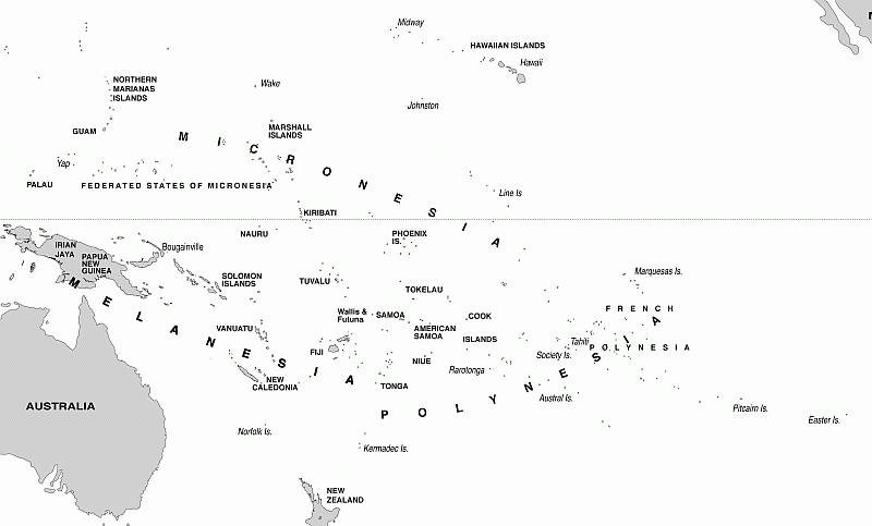
Figure 1. Map of the Pacific Islands region.
This paper does not include Hawaii, New Zealand, Australia or Easter Island, but all of the countries and territories that are under the auspices of the Secretariat of the Pacific Community (excepting Pitcairn Island). Map drawn by Max Oulten.
Altogether there are 21 political entities (excluding Pitcairn Island) ranging in political status from colonial territories of metropolitan countries through to the majority (14) which are fully independent nations (see Table 1).
Table 1. Some characteristics of PICs and Territories
Country |
Land Area |
Highest Elev. |
Island Type |
Popn. |
Political Status |
(Former) |
|---|---|---|---|---|---|---|
American Samoa |
199 |
964 |
V |
66,107 |
Territory |
USA |
Cook Islands |
237 |
652 |
V & A |
15,537 |
Free Assoc. |
NZ |
FSM |
701 |
791 |
V & A |
110,443 |
Free Assoc. |
USA |
Fiji Islands |
18,272 |
1,324 |
PB |
839,324 |
Independent |
UK |
French Polynesia |
3,521 |
2,241 |
V & A |
263,267 |
Territory |
France |
Guam |
541 |
406 |
V |
178,980 |
Territory |
USA |
Kiribati |
811 |
81 |
A |
97,231 |
Independent |
UK |
Marshall Islands |
181 |
10 |
A |
53,236 |
Free Assoc. |
USA |
Nauru |
21 |
61 |
RL |
10,163 |
Independent |
UK |
New Caledonia |
18,576 |
1,628 |
PB |
246,614 |
Territory |
France |
Niue |
259 |
68 |
RL |
1,549 |
Free Assoc. |
NZ |
Northern Mariana Is |
457 |
965 |
V |
62,969 |
Territory |
USA |
Palau |
444 |
242 |
V |
20,279 |
Free Assoc. |
USA |
Papua New Guinea |
462,840 |
4,509 |
PB |
6,473,910 |
Independent |
Australia |
Samoa |
2,935 |
1,857 |
V |
179,645 |
Independent |
NZ |
Solomon Islands |
28,370 |
2,447 |
PB |
517,455 |
Independent |
UK |
Tokelau |
12 |
5 |
A |
1,170 |
Territory |
NZ |
Tonga |
650 |
1,033 |
V |
102,724 |
Independent |
UK |
Tuvalu |
26 |
5 |
A |
9,729 |
Independent |
UK |
Vanuatu |
12,190 |
1,879 |
PB |
233,026 |
Independent |
UK/France |
Wallis and Futuna |
142 |
765 |
V |
15,472 |
Territory |
France |
a - Source of data: SPC (2008)
b - Source of data: Pernetta (1990)
c - A=atoll(s); PB=plate-boundary or continental island(s); RL=raised limestone island(s); V=volcanic high island(s)
d - Territory refers to a range of arrangements for countries that are not independent. Free Assoc. stands for Self Governing in Free Association with a metropolitan country (either New Zealand or United States).
The region has a total population of around 9.5 million, although around two-thirds live in Papua New Guinea. The regional land area is around 550,000 km2, over 80 per cent of which is Papua New Guinea, and a total of almost 29 million km2 of EEZ ocean area. The independent countries tend to maintain strong relationships with their former colonial power, although Australia and New Zealand have tended to develop closer ties with some former UK colonies such as Fiji, Kiribati, Solomon Islands and Tuvalu, than does the UK itself. Former colonial linkages are important as flows of relief from metropolitan countries reflect, to a certain extent, these earlier connections. The settlement of the region covers a vast period of time from around 40,000 years ago in Papua New Guinea (Groube et al., 1986) to less than two thousand years ago for the more remote islands to the east (Kirch, 2000). The first European to land on a Pacific Island was Magellan who reached Guam in the early 14 th Century and by the beginning of the 20 th Century all of the islands in the Pacific region were under some kind of control by a foreign government (Chappell, 1999). The first independent country was Samoa in 1962 although most of the independent countries achieved that status in the 1970s and 1980s.
As Figure 1 and Table 1 both indicate, the countries and territories of the Pacific Island region are highly diverse. Papua New Guinea (independent since 1975) dominates in terms of population and land area. However, it also has huge cultural diversity with over 800 languages being spoken, a broader resource base than the other countries, and the widest exposure to natural hazards ranging from climatic hazards such as frosts in the highlands and tropical cyclones in some outer islands and coastal areas to drought across the country, and geological hazards including earthquakes, volcanic eruptions and tsunami. At the other extreme, Tokelau, still a New Zealand territory, has a population of less than 1,500 people, is only a few metres above sea level, a land area of just a few square kilometres and exposure to tropical cyclones, droughts and high tide and wave events. Between these extremes lie a range of situations: single island countries, countries consisting of chains of atolls only a few metres above sea-level, those made up of various combinations of atolls and high islands, those comprised of volcanic high islands found in the central Pacific (sometimes in complex archipelagos spread over vast areas of ocean), and those which are made up of predominantly plate boundary islands (Nunn, 1994), which are sometimes referred to as continental type islands, along converging plate boundaries along the Pacific ring of fire. Thus there is a range of exposure to hazards (potential extreme events), potential for loss, and spatial complexity in disaster response (e.g. from isolated highland villages in Papua New Guinea and isolated outer islands in archipelagos to densely populated urban settings). These are all important issues for effective disaster response.
Many PICs are exposed to a wide range of natural hazards. Most lie in the zone north and south of the equator that is exposed to tropical cyclones, many islands in the western part of the region are located on the Pacific ring of fire and are subject to earthquakes and host a number of active volcanoes. Other hazards include tsunami, drought, land slides and frosts (in highland Papua New Guinea). Since 1990, ReliefWeb has recorded 88 'natural disasters' in the region, several of which impacted on more than one country. Of these, almost half (42) were tropical cyclones.
In this paper I use the term disaster risk management (DRM) to encapsulate both disaster management (DM) and disaster risk reduction (DRR). This is consistent with the United Nations International Strategy for Disaster Reduction terminology and DRM refers to both traditional disaster preparedness and measures that seek to reduce losses from disasters in the first place (ISDR, 2004). While there is considerable evidence that prior to western contact, some Pacific Island communities caused considerable environmental degradation (Kirch, 2000) it would appear that many island communities were thriving when first contacted by agents of the outside world, particularly from Europe. This suggests that they coped with the broad range of environmental extremes to which they were exposed with considerable success. It is likely that this was achieved through a number of means some of which may have been purposeful adjustments to environmental conditions but many of which may have been incidental, serving a myriad of other purposes but also contributing to community resilience. The main categories of disaster reduction were maintaining food security, having secure settlements and a variety of forms of intra- and inter- community cooperation (Campbell, 2006).
Food security was maintained through production of surpluses (which also facilitated inter-community linkages), having a high level of crop diversity, food storage and preservation, cultivation of resilient crops, having in ground stocks of famine foods and control of consumption. Secure settlements included locations in areas that were less hazardous – traditionally many communities lived on higher land, away from the sea – and building hazard resistant houses. The traditional bures and fales of Fiji, Tonga and Samoa, for example have a number of features that enhance their wind resistance. In Melanesia, along part of the earthquake prone 'ring of fire' many houses are of lighter structure, perhaps ensuring that damage from shaking will be limited. Inter community cooperation was sustained through the exchange of surplus production among communities. Quite often trading 'rings' covered considerable distances and enabled political and social alliances to be cemented. There is ample evidence that such networks were often called upon when food crops were devastated by natural disasters such as tropical cyclones and frosts (Campbell, 1990; Hocart, 1929; Waddell, 1983). Communities also coped by sharing losses and through rationing (Wilkes, 1845). This was facilitated by traditional political structures and kinship arrangements.
These measures came under different levels and types of pressure with the advent of contact and subsequent colonisation. New economic arrangements including the cash economy, social change including the introduction of a new religion, and changes to regimes of resource management all contributed to an erosion of many facets of disaster reduction. For example, traditional exchange systems became less important as the cash economy saw the introduction of new goods. Means of earning cash included migrating in search of employment or growing cash crops. The latter saw a reduction in subsistence crop production and in recent decades the more resistant taro and yam cultivars have been replaced by cassava (requiring lower soil fertility and labour inputs), a plant much more prone to damage from extreme winds. Many traditional networks and knowledge systems were challenged by the new religion and fell into disuse. Colonists and missionaries alike encouraged communities to move to the, more hazard prone, coast where they had easier access to, and control over, them. Today, many of the traditional activities that enabled communities to cope with disaster are no longer extant. The cash economy pervades the region and new social, cultural and political forms have been melded onto the traditional ones that remain. A key element in this transition has been the provision of disaster relief.
Examples of relief assistance can be found as early as the 1840s when the London Missionary Society sent provisions to the Cook Islands following two tropical cyclones. Most of the supplies turned out to be inappropriate and arrived long after the communities had recovered from the events (Lewis, 1999). A major tropical cyclone in northern and eastern Fiji in 1886 was followed by distribution of relief food supplies by the colonial government but the costs of the programme were charged against the tax refunds of the affected provinces (Campbell, 1985). It was not until the post World War Two era, however, that provision of relief by colonial governments became more regular and anticipated by affected communities (Campbell, 1985, 1990). By the time most PICs became independent, the provision of government assistance to affected communities had become commonplace. Whereas prior to colonisation, communities were, at least in combination with their neighbours, relatively self sufficient, they now had come to expect external assistance. As a result, a number of measures such as food storage and preservation and the use of famine foods had declined. It should be noted that disaster relief by colonial governments was often at the expense of other planned expenditure and rarely originated from additional revenue granted by metropolitan countries.
With independence a new set of relief arrangements emerged. A number of newly independent countries were soon affected by disasters and the new governments acted to ensure that communities were assisted. A pattern was established in which independent PICs would receive assistance from metropolitan countries (especially former colonisers). In some countries, such as Fiji, agencies were created to administer post-disaster response such as the Prime Minister's Hurricane Relief Committee which operated for well over a decade from 1972 into the 1980s. While initially various bilateral arrangements underpinned relief efforts multilateral assistance also grew in importance with a variety of United Nations Agencies providing various forms of relief. The most recent trend has been the growth of international non-governmental humanitarian organisations providing relief to disaster victims in the region. Moreover, these multilateral government and non-governmental organisations have become increasingly efficient and professionalised in the provision of humanitarian assistance. This is illustrated by the response to the Solomon Islands Tsunami of April, 2007. The mobilisation of international resources almost occurred within hours of the event, the internet enabling various organisations to launch appeals among their members. The event caused 52 deaths and 9000 people were affected (UNOCHA, 2007; IFRC, 2008a) and the total assistance given reported in the ReliefWeb Financial Tracking System (FTS) was US$5.6 million, though the amounts reported in ReliefWeb updates indicate that considerably more than this had been committed by various governments and agencies.
One of the problems with relief is that it is rarely given in an equitable manner. Different types of disasters, and disasters in different countries, receive different levels of international attention. An excellent example of this was the response to the 2007 tropical cyclone Guba which caused torrential rainfall and flooding in Oro Province, Papua New Guinea. The death toll (142) was almost three times that of the Solomon Island tsunami and 58,000 people required urgent assistance (IFRC, 2008b). This event was given limited international media attention and the FTS reported only US$1.6 million in assistance was made available.
But the biggest problems with relief lie in its effect upon the resilience of the communities that are assisted. In the Pacific region Ratu Sir Lala Sukuna, one of Fiji's greatest statesmen, expressed concern that communities should not be provided with relief as early as 1936 (McLean, 1977) and Waddell (1983) was particularly critical of the 1972-73 frost relief programme in Papua New Guinea which undermined local coping systems. At a broader global level Cuny (1983) also questioned the role of disaster relief. He felt that relief agencies downplayed local capacities and destroyed local coping mechanisms. More recently de Ville de Groyet (2000) observed that most international intervention occurs after neighbours and local agencies have already carried out most of the required assistance. Disaster relief has created perhaps a perpetual process in which resilience is reduced demanding even further provision of assistance. Unfortunately, resolving this problem is not easy as depriving assistance to those communities that have had their resilience weakened may have serious implications.
A second important trend in relation to DRM in PICs is related to urbanisation. Figure 2 shows the trends in urbanisation in the region. By international standards the Pacific Region has a relatively low rate of urbanisation: 23 per cent of the population, or 2,155,000 people, reside in urban areas, but this represents quite rapid recent growth and 10 of the PICs have over half of their populations resident in urban areas (SPC, 2008). Rapid urban growth has seen the emergence of significant squatter populations with limited access to services, vulnerable housing, restricted livelihood opportunities and often located in hazardous areas. However, with only a very few exceptions, DRM activities in the region have tended to have a rural focus.
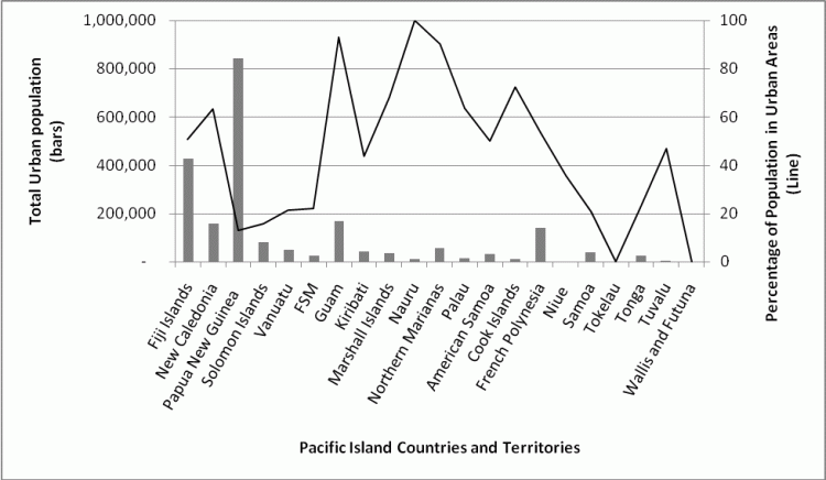
Figure 2. Urbanisation in PICs and Territories .
The bar graph shows the total numbers of urban residents in each country and the line graph shows the percentage of the population that is urban. Source of data: SPC (2008)
The development of urban hazard reduction through land-use planning has a number of limitations in PICs. A number of PICs have some form of urban planning and some of the larger urban areas have elected councils and municipal governments. But those planning mechanisms that exist are often characterised by limited levels of implementation (Connell & Lea, 2002). Most Pacific towns have restricted areas of freehold land and are built on or around villages with customary land rights which cannot be overridden. Moreover, many governments in PICs support traditions which are embedded in a rural ethos. The political incentive to engage with urban planning issues is further reduced in many countries where urban dwellers are registered to vote in their rural home areas (Commonwealth Local Government Forum et al., 2007). As well, in many countries it is perceived that the solution to urban growth is rural development and this has been emphasised in national planning priorities. A Pacific Urban Agenda (PUA) has been developed and incorporated into the Pacific Plan (the regional response to the Millennium Development Goals). Among its three main objectives the PUA seeks to integrate 'disaster management' into urban planning and governmental frameworks (Pacific Regional Workshop on Urban Management, 2003). To date, however, implementation has been slower than other elements of the Pacific Plan (Pacific Islands Forum Secretariat, 2007).
It must be acknowledged that the vulnerability of many urban residents in PICs is a result of broader sets of processes for which there a few simple solutions. Improving access to livelihoods is to a large degree dependent upon sustainable economic development, to which there are many constraints. This would perhaps stem the rate of rural to urban migration and provide opportunities for urban dwellers to find sources of income. Such issues are however, also addressed in the PUA where emphasis is placed on ways in which the informal economy may be enhanced.
One exception to the pattern of neglected urban planning and disaster reduction may be found in the case of Samoa where a Planning and Urban Management Agency (PUMA) was established in 2002 and legislation passed in 2004 to enable and use planning (Jones & Lea, 2007). A comprehensive coastal hazard mapping project has been conducted in Samoa and an integrated disaster risk management project, involving both government and communities, was incorporated into a major four year sustainable development programme for the management of coastal infrastructure (Roberts & Daly, 2008). This appears to have been one of the most comprehensive DRM activities in the Pacific Region and it could be argued that the death toll from the 2009 tsunami may have been considerably higher were it not for nationwide evacuation training exercises. Urban communities also develop informal structures which may play important roles in disaster situations and urban agriculture plays an important role in maintaining urban food security (Thaman, 1993).
At the regional level, the first concerted effort to improve disaster management began at the Pacific Islands Development Programme in the early to mid-1980s. This programme produced manuals (disaster management, post-disaster assessment) and had a number of in-country projects on strengthening local housing, particularly to increase resistance to strong winds. It held several workshops. In the early 1990s UNDRO established a South Pacific Programme Office (SPPO) to assist in the development of disaster management in the region. The SPPO initiated the South Pacific Disaster Reduction Programme which comprised a number of activities including annual meetings for National Disaster Management Officers, a series of manuals and in-country programmes. While the Pacific Island Development Programme started the process, the SPPO certainly bedded it in and this was a time when countries developed institutional mechanisms for natural disaster management and a regional cadre of trained and knowledgeable disaster managers emerged. Most countries now have legislation for disaster management and National Disaster Management Offices. A distinction made in 1994 by the Programme Office was that institutional arrangements for disaster management in the region were of two types: one with a strong emergency management orientation and typically linked to police departments and the second with a broader range of activities and more likely to embrace a disaster risk reduction approach. However, the former tends to have a stronger level of support from governments than the latter (SPREP, 1994).
From its outset the intention was for the SPPO to become integrated within a regional body and the Disaster Reduction Programme was taken over by the Pacific Islands Applied Geoscience Commission (SOPAC) in the late 1990s. SOPAC essentially provides scientific, particularly geological, services to the region. Under SOPAC the activities were placed in a Community Risk Programme, and a Comprehensive Hazard And Risk Management (CHARM) process was established. It is of interest that the disaster reduction programme was placed in this institution which has a largely science core (although its activities have broadened to encapsulate an overall sustainable development focus) to its activities. The current guiding document for SOPAC and the National Disaster Management Offices is the 'Framework for Action 2005 – 2015' which is the regional response to the Hyogo Framework for Action and the Mauritius Strategy, an international plan for sustainable development in small island developing states. The mission of the framework includes three elements: improved governance, mainstreaming of disaster risk management at all levels of governmental planning and decision making and strengthening partnerships among all stakeholders in disaster risk management (SOPAC, 2005). Steps are being taken to implement the framework: Regular 'Regional Disaster Managers Meetings' are now attended by large numbers of 'partners', mostly from the humanitarian sector (but with several committed to building DRR) and in 2008 a high level meeting of CEOs of Finance and Planning departments was held in conjunction with the Regional Disaster Managers Meeting to introduce them to the need for mainstreaming.
The other relevant regional programme is the South Pacific Regional Environment Programme (SPREP) which is more policy oriented and which has the climate change portfolio as one of its main activities. Interestingly, the International Strategy for Disaster Reduction has begun to promote the need to link climate change adaptation with natural disaster reduction which would require some integration between the two organisations.
Countries affiliated to the United States either as territories or as independent countries in free association with the United States have some differences from the other PICs. The three independent nations in particular (Palau, Federated States of Micronesia and Marshall Islands) have Compacts of Free Association with the USA. Until recently these compacts placed the three countries under the administration of the Federal Emergency Management Agency for post disaster assistance. Accordingly much larger amounts of relief have been made available to these countries than for the rest of the region. With the re-negotiation of the compacts these countries will now be under the ambit of the United States Office of Foreign Disaster Assistance, although the quantum of assistance is not anticipated, at least initially, to change.
In assessing disaster risk management in PICs it is clear that certain trends have emerged. While traditional systems of resource management and social organisation appear to have been characterised by high levels of resilience, the occurrence of colonialism and the subsequent emergence of nation states has seen considerable modification of these traditional patterns. In general disaster risk management may be characterised by three sets of activities. The first of these are typically measures, such as stopbanks and seawalls, which seek to 'protect' communities from extreme events. Often they encourage development in 'protected areas' and lead to even greater losses when they fail or supra-design events occur. The second set of measures are those that seek to avoid losses by avoiding areas that are hazardous or developing social mechanisms that reduce the losses caused by disasters and the third include measures that seek to offset the impact of disasters after they occur such as relief, recovery and rehabilitation activities and, for those who can afford it, insurance. In most PICs the third measure is the one which has the greatest uptake although in a number of countries there has been investment in the first of the measures, particularly in the form of seawalls. The second set of measures, which mostly involve land use planning, has the least support.
These measures tend to focus on what Wisner et al. (2004) call the unsafe conditions which create vulnerability to extreme events. From their perspective, reducing vulnerability requires addressing the underlying causes that lead to the creation of these conditions. In the Pacific Island Region these underlying causes may be seen in the processes of colonialism that saw traditional resilience undermined. In the post-colonial setting, this process has been further enhanced. Even the most isolated Pacific Island communities are participants in the global capitalist economy and traditional patterns of resilience continue to decline. As we have seen post-disaster relief is becoming increasingly rapid and efficient, but at the cost of local independence. It is difficult to see how the implementation of a hazard planning regime can achieve reductions in vulnerability while these processes continue to reduce resilience.
The future of natural disaster reduction in the region and of the vulnerability of PIC communities to hazards is unclear. There have been significant improvements in natural disaster management in the region, particularly since the establishment of the UNDRO (at the time), South Pacific Programme Office, and a cadre of knowledgeable natural disaster managers has evolved. At the most recent annual meeting of national disaster managers the ISDR credo of disaster risk reduction took a central role and an effort was made to introduce the need for the 'mainstreaming' of DRR to senior treasury and planning officials from the region. There are other factors, too, that need to be considered. Most (though not all) PICS have relatively high rates of population growth which is likely to increase the numbers of people exposed to future natural extremes when they occur. As we have seen, there are high rates of urbanisation in many of the PICs but relatively little has been achieved in terms of urban disaster reduction. With some notable exceptions, it is likely that this trend will continue and urban exposure and vulnerability will increase. Poverty is coupled with urbanisation in many parts of the region and while poverty, per sê, is not the sole contributor to vulnerability, lack of access to adequate livelihoods is a significant indicator. A major contributor to growing urban vulnerability will be the increase in squatter settlements and their populations. As indicated above, PICs are becoming increasingly reliant on international humanitarian assistance following disaster events. A question may be asked as to whether or not such levels will be maintained in the future, particularly in times of economic stress. Many PICs are experiencing considerable levels of local environmental change including among other processes, destruction of mangroves and coral reefs which play a major role in protecting coastal areas from storm surge and flooding. These processes may increase the magnitude of damage from future events. In addition, global environmental change, particularly global warming may bring about changes in the magnitude and frequency of some climatic extremes. It is possible that some communities will need to relocate (a process that is not uncommon within countries but has had limited success on an international basis (Lieber, 1977; Campbell et al., 2007). Internal relocation from rural to urban areas may place additional stresses on the latter. Given these trends, it is likely that PICs will experience increased vulnerability to natural disasters together with greater exposure to hazardous events.
There have been three key historical stages in disaster risk management in PICs. Initially it would appear that Pacific island communities maintained local control over disaster response through maintaining food security, having resilient shelter and through local and regional social, political and economic interdependence. Many communities are still quite resilient, especially in rural areas. Nevertheless, contact and colonisation saw a reduction in many of these measures, marginalisation of communities and increasing control over disaster response by colonial governments. We have now reached a stage where control of disaster response is mediated through independent national governments which are in turn dependent upon foreign donors for assistance. The predominant response has become relief oriented. The test for the upcoming decades of the new millennium is to move the focus to DRM. Despite the good efforts of regional organisations and national disaster management officers who are well aware of such a need, most governments have not yet accepted this challenge.
Campbell, J. (1985). Dealing with disaster. Hurricane response in Fiji. Honolulu: Pacific Islands Development Program, East-West Center / Government of Fiji.
Campbell, J. (1990). Disasters and Development in Historical Context: Tropical Cyclone Response in the Banks Islands of Northern Vanuatu. International Journal of Mass Emergencies and Disasters, 8(3): 401-424.
Campbell, J. (2006) Traditional Disaster Reduction in Pacific Island Communities. GNS Science Report 2006/38.
Campbell, J., Goldsmith, M. & Koshy, K. (2007) Community Relocation as an Option for Adaptation to the Effects of Climate Change and Climate Variability in Pacific Island Countries. Final report for APN project 2005-14-NSY-Campbell. Tokyo, Asia-Pacific Network for Global Change Research.
Commonwealth Local Government Forum, Economic and Social Commission for Asia and The Pacific, and Pacific Islands Forum Secretariat. (2007). The Second Pacific Regional Workshop on Urban Management, 23-25 April 2007, Nadi, Fiji Islands. Report. Nadi: Commonwealth Local Government Forum, Economic and Social Commission for Asia and the Pacific, Pacific Islands Forum Secretariat.
Connell, J., & Lea, J. P. (2002). Urbanisation in the Island Pacific : Towards Sustainable Development. London: Routledge.
Chappell, D.A. (1999). The Postcontact Period. In Rapaport, M. (Ed.) The Pacific Islands Environment and Society. Honolulu, Bess Press.
Cuny, F. (1983). Disasters and Development. New York, Oxford University Press.
De Ville de Groyet, C. (2000). Stop Propagating Disaster Myths, Lancet. 356, 762-764.
Groube, L., Chappell, J., Muke, J. & Price, D. (1986). A 40,000-year-old human occupation site at Huon Peninsula, Papua New Guinea. Nature. 324, 453-455.
Hocart, A. M. (1929). Lau islands, Fiji. Bernice P. Bishop Museum Bulletin. No. 62.
International Federation of Red Cross and Red Crescent Societies (IFRC) (2008a). Solomon Islands: Tsunami and Earthquake. Operations Update No. 7. 19 May, 2008. http://www.reliefweb.int/rw/RWFiles2008.nsf/FilesByRWDocUnidFilename/MUMA-7ES3GU-full_report.pdf/$File/full_report.pdf (Accessed 17 Sept 2008)
International Federation of Red Cross and Red Crescent Societies (IFRC) (2008c). Papua New Guinea: Cyclone Guba. Operations Update No.4. 31 July, 2008. http://www.reliefweb.int/rw/RWFiles2008.nsf/FilesByRWDocUnidFilename/YSAR-7H4LHZ-full_report.pdf/$File/full_report.pdf (Accessed 22 Sept 2008)
International Strategy for Disaster Reduction (ISDR) (2004). Living with Risk: A global review of disaster reduction initiatives. Volume 2 Annexes. New York, United Nations.
Jones, P. & Lea, J. (2007). What has Happened to Urban Reform in the Pacific? Some Lessons from Kiribati and Samoa. Pacific Affairs. 80(3), 473-491.
Kirch, P. (2000). On the Road of the Winds. An Archaeological History of the Pacific Islands Before European Contact. Berkeley, University of California Press.
Lewis, J. (1999). Development in Disaster-prone Places. Studies of Vulnerability. London, Intermediate Technology Publications.
Lieber, M. (ed.) (1977). Exiles and Migrants in Oceania. Association for Social Anthropology in Oceania Monograph Series. Honolulu, The University Press of Hawaii.
McLean, R. (1977). The Hurricane Hazard in the Eastern Islands of Fiji: An Historical Analysis, 1875-1975. In H.C. Brookfield (Ed.) The Hurricane Hazard: Natural Disaster and Small Populations. UNESCO/UNFPA Population and Environment Project in the Eastern Islands of Fiji. Island Report No. 1. Canberra, Australian National University, Development Studies Centre.
Nunn, P. (1994). Oceanic Islands. Oxford, Blackwell.
Pacific Islands Forum Secretariat. (2007). The Pacific Plan Annual Progress Report, 2007. Suva, Pacific Islands Forum Secretariat.
Pacific Islands Applied Geoscience Commission (SOPAC) (2005) A Framework for Action 2005 – 2015. SOPAC Miscellaneous Report 613.
Pacific Regional Workshop on Urban Management. (2003). Pacific Regional Workshop on Urban Management. Nadi, Pacific Regional Workshop on Urban Management.
Pernetta, J. (1990). Projected Climate Change and Sea Level Rise: A Relative Impact Rating for the Countries of the Pacific Basin. In Pernetta, J. & Hughes, P. (Eds), Implications of Expected Climate Changes in the South Pacific Region: An Overview. UNEP Regional Seas Reports and Studies, No. 128. pp. 14-24.
Roberts, G. & Daly, M. (2008). A Practical Exercise in Mainstreaming DRM in the Pacific. A Case Study from Samoa. Paper presented at the 14 th Regional Disaster Managers Meeting, Nadi, 21-22 July, 2008.
Secretariat of the Pacific Community (SPC) (2008). Pacific Islands Populations 2008. Noumea, Secretariat of the Pacific Community.
South Pacific Regional Environment Programme (SPREP). South Pacific Programme Office United Nations Department of Humanitarian Affairs, and Emergency Management Australia (1994) Natural Disaster Reduction in Pacific Island Countries. Report to the World Conference on Natural Disaster Reduction. Macedon, Emergency Management Australia.
Thaman, R. (1993). Pacific Island urban agroforestry. In Clarke, W. and Thaman, R. (eds), Pacific Island Agroforestry: Systems for Sustainability. Tokyo, United Nations University Press. pp. 145-156.
United Nations Office for the Coordination of Humanitarian Affairs (UNOCHA) (2007). South Pacific Tsunami - April 2007. OCHA Situation Report No. 14. United Nations Office for the Coordination of Humanitarian Affairs (OCHA), 16 Apr 2007. http://www.reliefweb.int/rw/rwb.nsf/db900sid/YZHG-72BR94?OpenDocument&rc=5&emid=TS-2007-000042-SLB
Waddell, E. (1983). Coping with Frosts, Governments and Disaster Experts: Some Reflections Based on a New Guinea Experience and a Perusal of the Relevant Literature. In K. Hewitt (Ed.), Interpretations of Calamity From the Viewpoint of Human Ecology. Boston, Allan and Unwin. pp. 33-43.
Wilkes, C. (1845). Narrative of the United States’ Exploring Expedition. Vol. III. Suva Reprinted Fiji Museum (1985). Original publication details: Philadelphia: Lea and Blanchard.
Wisner, B., Blaikie, P., Cannon, T. & Davis, I. (2004). At Risk. Natural Hazards, People's Vulnerability and Disasters. London, Routledge.
| Comments to Trauma.Webmaster@massey.ac.nz Massey University, New Zealand URL: http://trauma.massey.ac.nz/ |
Disclaimer
Last changed
5 February, 2010
|