 |
The Ruapehu
lahar emergency
|
| |
The Ruapehu
lahar emergency
|
The Ruapehu lahar emergency
response plan development process:
An analysis
Ian GalleySchool of Psychology
|
Graham Leonard Institute of Geological and
|
David JohnstonInstitute of Geological and
|
Richard BalmPO Box 1955
|
Douglas PatonSchool of Psychology
|
Abstract
Achieving a high state of emergency response preparedness is imperative as the breach of the barrier restraining Crater Lake, Mt Ruapehu, New Zealand draws near. A number of key planning issues are identified here that will influence the effectiveness of the Emergency Response Plans (ERPs) currently at various stages of completion for the agencies that must respond to this event. A Southern Response Lahar Planning Group of organisations with statutory response obligations has been convened to facilitate a unified response. The tephra barrier formed during the 1995-96 eruptions at Ruapehu, and the lake has been gradually filling since (it was emptied during the eruptions). If the barrier breaches catastrophically it will send a lahar (dense volcanic-ash-saturated flash flood) down the Whangaehu river posing a hazard to life which is particularly high at several points down stream. A similar lahar in 1953 damaged the rail bridge at Tangiwai and lead to the deaths of 151 train passengers.
The Eastern Ruapehu Lahar Warning System (ERLAWS) utilises three separate lahar sensors high on the mountain to automatically trigger lights and gates at the key road bridge and rail bridge at Tangiwai, to give warning and activate response agencies’ response plans. The emergency response involves a set of over a dozen agencies each with distinct but interrelated responsibilities in the event. Once the alarm is triggered it has been calculated that the lahar will reach the Tangiwai road and rail bridges within approximately 90 minutes. This event is somewhat unique because (a) it has a relatively short window of probable occurrence, a matter of months, once the lake rises above the base of the tephra dam, and (b) once the alarm is triggered the core response agencies have a particularly short period of time (< 90 minutes) in which they must respond at Tangiwai (the time is shorter on the Desert Road and the mountain itself).
The key issues that will influence the effectiveness of the ERPs are grouped into three categories: (1) coordination issues, (2) communication and information management issues and (3) training issues. These are in addition to physical factors beyond the scope of this study (e.g. equipment performance, human error, event size). The most imperative coordination issue to accommodate is the diversity of organisations involved (Department of Conservation, Police, power generation and transmission, TranzRail, district and regional government, roading and a variety of others), several of which have multiple functional boundaries of authority within themselves. This diversity exacerbates the other key issues: perceptions of the required response and the nature of the event will differ between organisations and individuals; lines of, and protocols for, communication need to be explicit within and between organisations; and loss of knowledge, experience and interpersonal connections occur with staff turnover, which is relatively frequent (often every few years) in the larger organisations. Training must address these issues, and others outlined herein, to develop a common mental model of the event and the response. In doing this it will be most effective to conduct full field exercises, and repeat them as needed.
The complexity of developing and maintaining effective ERPs is highlighted. It is clear that a reliable and effective warning system is not enough in isolation. An integrated system of (a) warning system maintenance and enhancement, (b) education, (c) research and (d) response planning is necessary. This integrated system is seen as an essential model for warning system development for a wide range of hazards and this event, therefore, should serve as a model and case study for future integrated warning-system/response implementation.
The Ruapehu lahar emergency
response plan development process:
An analysis
Purpose and Scope
This study identifies and discusses important issues influencing effective emergency response planning for a lahar produced by the collapse of a tephra barrier (layer) deposited at the Mt Ruapehu Crater Lake outlet by the 1995-96 eruptions. This layer will allow Crater Lake to refill to a level ~ 7 m above its former level (2530 m asl.) and may collapse suddenly releasing ~ 1.4 million m3 of water into the Whangaehu valley, generating a lahar (volcanic debris flow) similar to, but possibly much larger than, that of 1953 (which caused the Tangiwai disaster, see below). Many of the points raised here are also more widely applicable to emergency response planning in general. For example, effective response requires the coordination of actions across a range of agencies. This event thus provides an opportunity to examine operational issues associated with the use of Coordinated Incident Management Systems. The Crater Lake tephra barrier collapse lahar hazard is somewhat unique for a number of reasons: (1) it is predictable to within a matter of months, which is relatively precise for a natural event, (2) it is a recurring event on Mt Ruapehu, which historically has led to one of New Zealand’s worst disasters, (3) compared to the short, predictable, nature of the event the return period is relatively long (~ > 50 years), (4) response to the event requires the coordination of a particularly large and diverse range of organisations, (5) Crater Lake is part of New Zealand’s first National Park which has World Heritage status and (6) the summit of Ruapehu and Crater Lake have a range of particularly strong cultural values.
Background to lahar hazard and warning system
Mt. Ruapehu is an active volcano with an extensive history of eruptive activity spanning at least the last 250,000 years. The most recent eruption began in January 1995 with the first significant eruption occurring on 29 June. The main eruption sequence commenced on the 18th of September and continued through November of that year (Johnston et al., 2000). After a period of quiescence eruptions recommenced in June 1996 and continued until September. During these eruptions approximately 30 lahars (volcanic debris flows) were sent down the slopes of the mountain and Crater Lake was emptied for the first time since 1945. A timeline for key events discussed here is given in Figure 1.
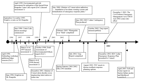
Figure 1. Time line showing key dates in lahar response plan development process
A key outcome of the 1995-96 activity was the build up of a tephra (See footnote 1) layer over the natural lake overflow channel at the head of the Whangaehu valley (Fig. 2). Studies of the changes to the Crater Lake area caused by the 1995-96 eruptions were carried out to access the stability of the crater rim (Hancox et al., 1997; 1998). These studies concluded that a potentially hazardous situation existed, similar to that of 1953, after the 1945 eruptions. There was a clear possibility of another tephra barrier collapse lahar when the lake refilled. However, because glacial recession had removed the restriction of the Crater Basin glacier (and tunnel under glacier), the potential lahar could be much larger (50 – 75 %) at Tangiwai where the rail bridge had been destroyed in 1953.
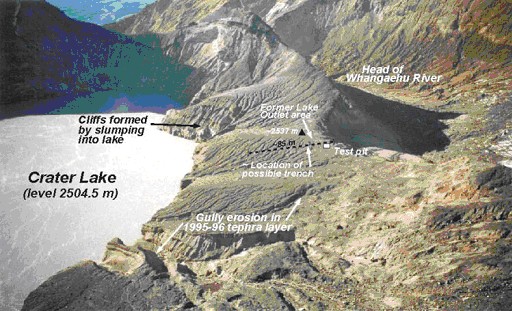
Figure 2. The tephra barrier to Crater Lake that formed
after the 1995-96 eruptions.
Note location of possible trench excavation. From Hancox et al. (2001).
The tephra layer is a highly permeable and relatively weak structure composed of layered ash, scoria and blocks approximately seven metres thick. As Crater Lake refills it will encounter this barrier and water will seep through permeable layers in it and begin to erode it internally. If the lake fills to the top of the barrier the flow of water from the lake, because of the very small catchment, will probably not be adequate to gradually erode the barrier from the top (Hancox et al., 1997; 1998). The barrier will instead likely remain at full or nearly full height until it is sufficiently weakened through internal seepage and/or sloughing from the lake and southern slopes of the barrier for it to suddenly collapse. Recent scientific investigations (Fell and Foster, 2003) have judged that the barrier will very likely fail as the lake level approaches 2536m asl. (~ 6.5 m head) or beyond, and that the barrier breach will then develop quickly. Fell and Foster (2003) estimate that a breach will likely develop within 15 to 45 minutes, but this remains uncertain. Given catastrophic collapse of the barrier, a lahar will travel down the normal Whangaehu lahar path (Fig. 3), then south roughly parallel to SH1. It will then head through the Tangiwai area and west to reach the sea south of Wanganui. Figure 4 presents a map of potential lahar courses. In a very unlikely worst-case scenario, requiring rapid erosion of the hard ash rim under the dam, water discharge would be up to 3 times larger than that involved in the 1953 Tangiwai disaster (See footnote 2) (Fig. 5). The most likely lahar would be about 90 % larger and 10 to 30 % deeper than that in 1953 based on complex numerical modelling of lahars and (a) the constitution of the dam, (b) likely failure mechanisms, (c) the character and amount of source material in the upper steep Whangaehu channel that will bulk the lahar and (d) attenuation across the gentler flood-plain slope once the lahar passes the Whangaehu gorge (Keys, 2003).
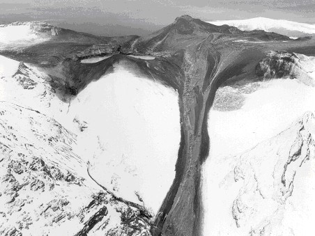
Figure 3. Eruption-generated lahar from Crater Lake
down the Whangaehu lahar path (centre bottom).
Note that the tephra barrier collapse lahar will originate from the top of
the valley
in the upper left of the image, below the left side of the Crater Lake.
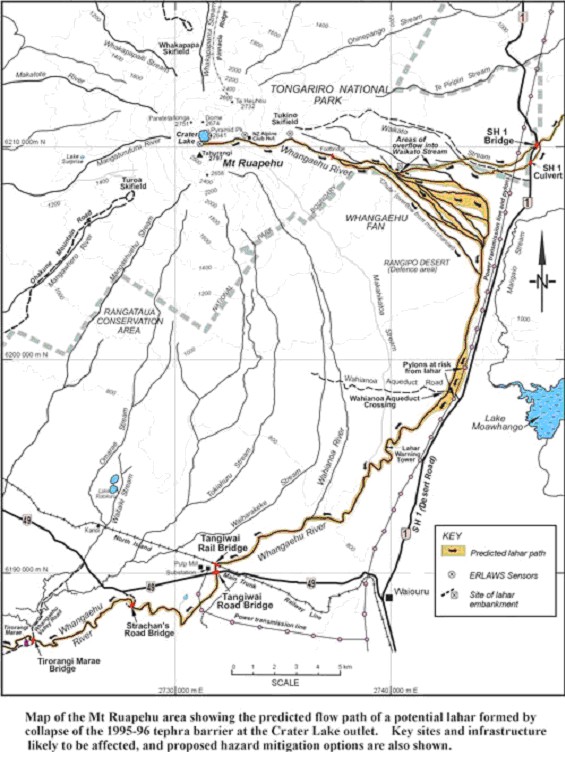
Figure 4. Map showing lahar paths. From Hancox et al. (2001).
Towards the end of the 1995 eruption sequences the existence of the tephra barrier and the changes occurring at the Crater Lake were known. However, the ramifications of these changes and the potential for a catastrophic lahar almost twice the size of the 1953 event had not become apparent until 1997 (Hancox et al. 1997) and the likely effects until 1998 (Hancox et al., 1998).
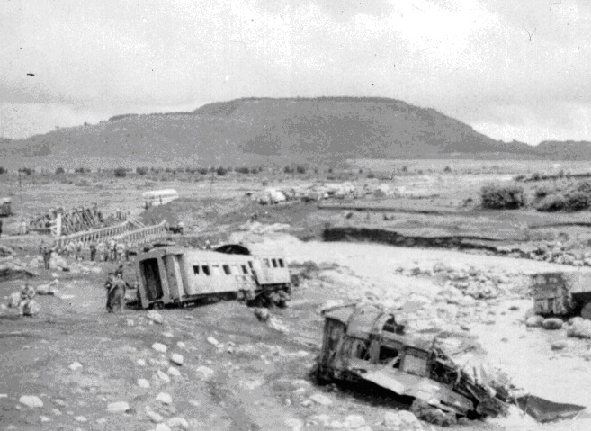
Figure 5. Damages train carriages after the 1953 Tangiwai disaster. The lahar produced by a catastrophic failure of the barrier restraining the Ruapehu Crater Lake destroyed the rail bridge at Tangiwai. 151 people died as the train they were travelling in fell into the Whangaehu River.
These reports indicated the potential for significant damage to the rail and road bridges at Tangiwai, and also road bridges and power pylons on the Desert Road. There was also the strong possibility of lahar overflow into the Tongariro River and Lake Taupo. To prevent these damages and effectes, Hancox et al. (1997) recommended that a short tunnel be excavated through the tephra barrier at the Crater Lake to prevent the lake from rising above its former overflow level (2530 m), thereby removing the potential for catastrophic barrier collapse lahar. Following the Draft Assessment of Environmental Effects report (prepared in 1998), the Department of Conservation (DoC) went on to produce the Environment and Risk Assessment for the Mitigation of the Hazards from Ruapehu Crater Lake (DoC, 1999), with an independent review by Neall (2000). The DoC report recommended that no engineering intervention at the tephra barrier be allowed. Instead it recommended (a) the development of a warning and response system, (b) the development of revised hazard response plans in potential lahar zones and (c) further investigation of a bund (Fig. 6) (first recommended by Hancox et al., 1995) at the spill-over point of the Whangaehu River into the Tongariro River. This bund was completed in early 2002, around the same time that the Eastern Ruapehu Lahar Alarm & Warning System (ERLAWS) was put in place (following recommendations by Goodwin et al., 2001 and Gledhill and Scott, 2001). Figure 7 shows the location of ERLAWS sensors. The ERLAWS system is functional, and is close to achieving the expected optimum levels of efficiency following a year of performance monitoring, and problem identification and rectification (H. Keys, pers comm., 2003). Figure 8 shows ERLAWS automatic lights installed with warning signs and manual gates on SH49 at Tangiwai to exclude traffic from the Whangaehu River flood channel once a lahar is detected up stream.
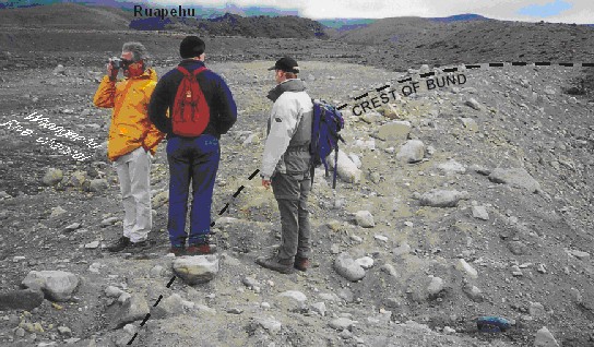
Figure 6. Bund constructed at spill-over point of the Whangaehu River into the Tongariro River.
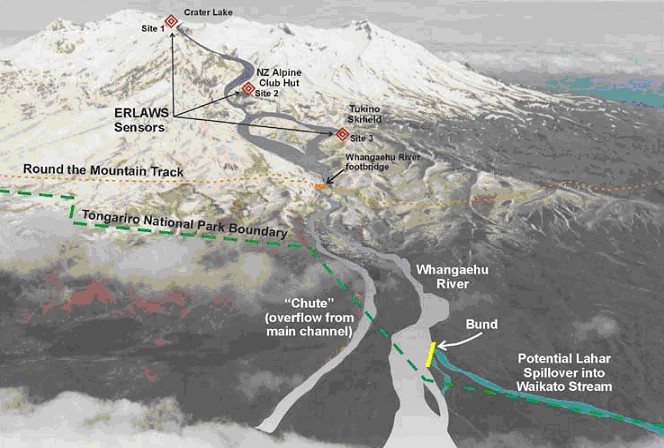
Figure 7. Aerial photo of the upper Whangaehu catchment on Mt Ruapehu showing the location of the bund and ERLAWS sensors. From www.doc.govt.nz/.
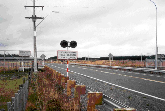
Figure 8. ERLAWS warning measures on SH49 at Tangiwai,
consisting of signs,
automatic flashing lights and gates (manual closure required).
At the time of the 1999 DoC report, the advantages and disadvantages of non-intervention at the Crater Lake were considered to be:
A non-interventionist, warning/hazard-planning response to the situation was subsequently adopted in late 2001, when the Minister of Conservation declared that no engineering work would be conducted at the crater rim. Issues including (a) the views of conservation and recreational groups and local iwi (Ngati Rangi and Ngati Tuwharetoa) and (b) conservation obligations. However, there has since been some dissatisfaction with this from some local government agencies, government opposition and public asking the government to take action to prevent the lahar from occurring (e.g. main front page story, 22nd December, 2003, The Dominion Post, Wellington).
To assist in the development and evaluation of warning and response plans the Ministry of Civil Defence and Emergency Management (MCDEM) commissioned a quantitative risk assessment (the Ruapehu Lahar Residual Risk Assessment, Taig, 2002; hereafter known as the Taig Report). The brief for the assessment was: ‘what is the risk of at least one person being killed as a result of a lahar generated by the collapse of the tephra barrier at the Crater Lake on Mt Ruapehu’? The analysis was carried out in May and June 2002. The Taig Report concluded that estimates of the probability of casualties are difficult to make with any certainty, but with the implementation of appropriate safety procedures and response plans “…we can be confident on reducing this residual risk to a less than 10% chance of somebody being killed as a result of the Lahar.” (Taig report, July 2002, p. ii). Since the publication of the Taig report a substantial amount of work has been conducted on enhancing and strengthening the emergency response plans for this event. However, as noted in the report, risk to the public can never be managed with absolute certainty.
As mentioned above, assets under threat are the national electrical grid transmission pylons near the aqueduct site, the bridges of the main trunk railway and State Highway 49 at Tangiwai, the Tangiwai memorial structures, Strachan’s Bridge (a small farm bridge) and a small rural bridge near Tirorangi Marae. Depending on the nature of the lahar, the flow will take approximately 1.5-2 hours (Taig, 2002) to reach the Tangiwai bridges and memorial. There is also the possibility of a lahar crossing over into the Waikato stream and travelling north, creating a hazard along the Tongariro River, to the Blue Duck population, to the Rangipo Power Station and to Lake Taupo. This possibility is in theory virtually eliminated by the construction of a bund, mentioned earlier.
The issues faced from a Crater Lake lahar event are quite unique for a number of reasons:
It should be noted that a separate lahar hazard to skiers at Whakapapa Ski Area, on the northwestern flank of the mountain, is posed only by a volcanic eruption (Leonard et al., 2004). In 1995 water from the lake was erupted over the relatively high summit ridge above the ski field and the resultant lahars narrowly missed ski structures. Similar lahars in 1969 and 1975 damaged ski structures. As publicity of the Crater Lake dam-breach lahar hazard discussed here increases the public are increasingly confusing it with the hazard to the ski area (Leonard et al., 2004), which is a separate issue with a different cause. The ski area has an Eruption Detection System which is independent from, and unrelated to, the ERLAWS system. Given the high level of public confusion noted by Leonard et al. (2004), some staff within the response agencies discussed here may also confuse the barrier-breach hazard with that at the ski area.
Response Plan Development
Response plans have been prepared by local government (Ruapehu District Council and Taupo District Council) for the southern and northern areas likely to be affected by the lahar. Separate response plans were necessary because the nature of the hazard, and the probability of its occurrence, are both quite different in the two areas. The main area affected is covered by the Southern Response Plan, which takes in the path in the Whangaehu River, from Crater Lake to the sea. This flood path will carry the bulk of the tephra barrier collapse lahar during all future events (including eruption lahars). The Northern Response Plan will only come into effect if the lahar overtops or breaches the bund between the Whangaehu and Waikato Streams, and enters the Tongariro River and Lake Taupo – considered to be a very unlikely event (Fell and Foster, 2003). The northern lahar path is shorter with a smaller affected area and contains assets (Rangipo Power Station, Tongariro-Taupo forestry and ecosystem) different from those to the south.
A Southern Ruapehu Lahar Planning Group has been convened (as of November 2003) by of the organisations with a role in planning for the Crater Lake barrier collapse lahar (including RDC, MCDEM, horizons.mw and the Police). This group is now charged with coordinating the response and involving other key agencies as necessary. It is also charged with coordinating training and checking that preparations for other agencies roles are being completed in full and correctly. The Ruapehu District Council (RDC) has taken responsibility for primarily overseeing the development of the coordinated, multi-agency Southern Response Plan (unpublished, held by the council). RDC has developed its own response plan and is awaiting finalisation of the response plans for the other organisations involved. One issue that could arise concerns the potential of inconsistent expectations of the various agencies affected because of a failure to consider inter-agency needs, and the development of plan components to deal with differences in responsibilities and roles. Because the Crater Lake is currently at 90% full (February, 2004), slow production of plans will reduce the amount of time available for coordination, training and education. The latter is important both as a test of agency activity, but also to ensure that any coordination issues are identified and rectified prior to the event.
The Taupo District Council (TDC) has taken responsibility for overseeing the development of the Northern Response Plan (in the case of the lahar entering the Waikato Stream). In this scenario Genesis Energy will initiate their in-house resource protection plans. Genesis have developed their response plan and have presented the document to TDC’s Emergency Management Subcommittee for discussion.
Many of the organisations involved are taking a general approach to their response plans in which many components are applicable to other future hazard events, rather than designing plans specifically for the barrier-break lahar alone. This may be beneficial as it will enable this experience, and the knowledge gained from it, to be utilised in the future. However, whether or not a general response plan has any negative aspects cannot be determined until the plans are received and evaluated. It should be expected that all plans recognise the special and specific nature of the lahar event that it is expected to cope with.
In addition to the response agencies and other organisations (including GNS and universities), there are a number of community groups (such as kayakers, anglers, trampers and local communities) whose members may be affected by the event. Communication and coordination needs to be maintained with these groups.
The lahar response process is made more complex by the potentially wide geographic extent of the affected area. This is reflected in the number and range of organisations that are likely to be involved in the response to the event. The affected area includes four district councils, two regional councils and crosses the functional boundaries of a number of the organisations involved. In addition to raising problems associated with multi-jurisdictional management and coordination, geographical factors raise several operational issues. For example, this context requires (a) high levels of inter-agency and inter-jurisdictional planning, (b) the development of distributed decision making procedures (defining geographic and hierarchical locations within and between agencies) and (c) the capabilities to utilise these procedures effectively during operational implementation of the plan.
The communications issues inherent in managing a coordinated response by so many bodies are made more complex by the fact that functional boundaries of several agencies (e.g. Police and DoC) cross the affected area. Organisations are understood to be working to manage these internal coordination issues. Linkages have also been forged between organisations to improve coordination, for example between DoC and Genesis Energy, and between the NZ Army and Good Health Wanganui. Most of these agreements at this stage consist of letters of understanding (unpublished, held by the individual agencies). As a positive bi-product of the response planning process a network of personal relationships is also being built up between individuals across the various organisations.
The involvement of so many groups of such a varied nature produces challenging communication and coordination issues. There are also a range of goals and objectives that each is responsible for. Additional analysis is required to identify these objectives and to assess any conflicts between agencies. There is a particular need for an analysis of the degree to which the activities of response agencies (including Genesis Energy) are dovetailed with the response plan objectives of agencies with recovery responsibilities. From a response perspective, the degree of informational interdependence between agencies also needs to be examined to ensure that relevant information will be communicated in a timely manner (see ‘Communication and Information Management’ below). Appendices 1 and 2 give full lists of organisations involved, with details of the response duties of each.
Despite the many obstacles and challenges, significant progress has been made toward an effective management strategy for this natural hazard event. The major parties involved have been active in developing their plans and are making a concerted effort at moving toward this end (communications to R. Balm at Planning Group meetings, 2003-04).
A large number of organisations are potentially involved in this event (refer above list and Fig. 8). The nature of these organisations varies widely, and they include emergency response, civil planning and infrastructure maintenance agencies. Few of these have experience working together and none have previous experience of collectively responding to any historical lahar event.
The organisations involved also differ in terms of governance, structure and public accountability, and some have less clear lines of external communications than others. The hierarchical and bureaucratic nature of some of the larger organisations can make it more difficult to adopt the kind of organisational structure required for effective crisis response. There is a risk that bureaucratic organisations will respond by reinforcing and emphasising routine structures, procedures and reporting practices in ways which complicate their response.
It is important to ensure that these agencies have developed crisis management procedures and that they have provided their staff (including senior managers and elected representatives) with the training required to implement crisis response. Individuals who will be involved in the lahar response have a range of backgrounds from those focussed on response planning to those with a more scientific and thus research-based perspective.
The heterogeneous nature of the organisations and individuals involved will produce a emergency response that often varies between them. For example, the organisations that are not dedicated emergency response agencies may have differing levels of commitment, response times, staff and resource availability, and also varied understanding of the processes and issues involved in conducting an emergency response operation. Some, particularly commercial organisations, will also have to reconcile commercial imperatives with their role in reducing environmental, physical, and human losses. This will, along with the magnitude of the event impact, affect the duration of the recovery. Contingency planning based on the scenarios outlined in the Taig Report could be used to outline the kinds of issues and the time frames that may arise from such heterogeneity.
Functional Boundaries of Authority
Functional boundaries exist within many large organisations, these are structural but are often defined geographically. For example DoC is divided into conservancies (functional bodies) by geographical functional boundaries – the key conservancy for this response is Tongariro/Taupo. Multiple functional bodies within many of the organisations involved (especially DoC, Police, Transit, local government, Ministry of Defence, Opus and Civil Defence), combined with the extensive geographic area potentially affected by the lahar, result in complexities in attributing roles and responsibilities. At present there are still many areas of uncertainty in terms of roles and responsibility of each functional body (discussed at Planning Group meeting, February 2nd, 2004).
Poorly defined boundaries between functional bodies potentially leave dangerous holes between response plans. In emergency situations this can lead to two organisations trying to do the same task, or having a task neglected because one assumes that the other is responsible for it. For example, a recent New Zealand Civil Defence exercise (Poseidon’s Revenge, Martin et al., 1999) saw separate Civil Defence groups sending evacuees in opposite directions crossing one another’s paths. Communications difficulties may occur when two organisations are forced to communicate with each other in unanticipated ways or intensities. The analysis process should thus address information management and communication across functional boundaries (including clarifying issues in regard to technical terms, jargon, and consistency of communications equipment and communication frequencies).
Steps needed to resolve role and responsibility uncertainties between functional bodies may include:
Execution of these steps will enable response plans to be more specific in terms of who is responsible for what, and to establish lines of authority and communication. As well as the clear importance to the response in a real emergency, it will also make simulation exercises more efficient and allow them to more accurately model reality and hence more likely to work in that real emergency.
A literature review of information from the relevant legislation, and publication and dissemination of the conclusions drawn, would be helpful. Also, clarification of hierarchical structures amongst the organisations involved would identify who should order any recalcitrant body to adopt an area of responsibility. If such an order were necessary, it would indicate a degree of unreliability in that body and would have to be accommodated in risk estimations. . Given the urgency of the response, and the limited time frame available for discussion, response agencies may benefit from a review of their policy and practices in regard to delegating authority to ensure that appropriate actions can be implemented in a timely fashion.
Individual and Organisational Perceptions
With the long return period of events such as volcanic eruptions and lahars it is hard to retain corporate knowledge. The return period for a 1,000,000 m3 (i.e. reasonably substantial) lahar in the Whangaehu River is 20 to 50 years (Hancox et al., 2001). Those involved in one event may have left before the next one and so the lessons that were learnt are lost from that organisation. It is critical that all events are documented with a written record, that debriefs are held and written up, and changes to systems are made immediately. A number of DoC and RDC personnel experienced the 1995-96 Ruapehu eruptions and this has helped in determining the relative significance of different aspects of a lahar event.
The use of technical language has been seen to have an impact on the ability to transmit information to the public from historical events, including the 1995-96 eruptions. This factor is critical and efforts have been made to mitigate this effect by developing a shared language of event-specific terminology, for example the Volcanic Alert Scheme (Scott et al., 1995).
Education Improves Coordination
Developing shared understandings and perceptions of the situation amongst organisations involved can be achieved through a programme of education and information dissemination.
Education has a number of benefits.
Recognising the value provided by education, RDC has initiated an educational program. As part of this, in November 2002 RDC presented an “information road-show” to key organisations. This process succeeded in addressing areas of information shortfall within several organisations. The knowledge areas that needed addressing varied between them. The road show also revealed a significant gap between the perceptions of members of many of the organisations and the reality of the situation. This gap in perception was evident even amongst some employees of the RDC itself. However, it must be noted that the provision of information alone is not sufficient to enhance inter-agency collaboration or their ability to function collaboratively in crises. Development of such collaboration also requires comprehensive real-time simulations designed to critically examine agency and inter-agency capabilities and their collective response.
The present level of understanding of the situation within many organisations is concerningly low. The Taig report noted a knowledge and perception gap in June 2002, observing that “…there does not appear to have been a shared appreciation of what is involved, and what it costs, to provide high reliability warning and response arrangements to protect life…” (p. iii). While this situation may have subsequently improved, it will inevitably impact on the quality of future response plan developments if not effectively managed.
Organisational education as described above is an on-going process, and experience so far indicates an ongoing need for effective education.
Anecdotal evidence indicates that the Crater Lake situation has low visibility amongst the general public, with correspondingly low levels of concern expressed by them. An education campaign involving the distribution of pamphlets, and possibly other methods, is envisaged with increasing activity as alert levels rise.
Potential Impact of Limited Education or Situational Awareness
A poor standard of event-specific education amongst involved organisations is likely to produce at least two major potential deleterious impacts:
Complacency may manifest itself in reduced motivation towards the project, less resource commitment, and lowered commitment to developing practical organisational and inter-agency competencies. The relatively short time window (by natural disaster standards) from now until the onset of the event (within a few years) can reduce the opportunity for complacency to set in, but only if there is a high level of commitment to developing and testing appropriate response procedures and mechanisms.
To manage complacency a realistic awareness of the present situation should be maintained, both in terms of the threat and the status of the development of the response plan. The Taig report called for a plan development monitoring process that included “…clear milestones against which to measure progress.” (p.79). A critical path system of objective goals or milestones would be one way to assist in maintaining a clear and realistic view of the development process. It is important to remain aware of the potential for complacency throughout planning, simulation and education processes. This process could also be sustained by central government (i.e., the Ministry for Civil Defence and Emergency Management) commitment to using this event as a trial of key mechanisms such as CIMS. The relatively predictability of this event, particularly in regard to its timing and nature renders it particularly amenable to such an evaluation.
Human Resource Issues
The rapid and unpredictable (beyond a window of a few months) onset means organisations must react quickly to a lahar and (probably) be on a heightened state of alert for a period prior to the event. While this natural hazard is at the more predictable end of the event occurrence spectrum, there is still an extended period of time (measured in a time frame of several months) in which the tephra barrier at Crater Lake could fail. The Emergency Management Plan includes levels of readiness based on the level of the Crater Lake (Appendix 2). These alert levels are based on the assumption that a higher level of risk is associated with a higher lake level. As level rises agencies will make readiness preparations (Appendix 2) as detailed and agreed to in the Emergency Management Plan. Levels of heightened readiness cannot be maintained indefinitely. The period predicted for lahar occurrence could be several months and there is also no guarantee that the lahar will not be delayed until after this time. Organisations will inevitably need their resources (human and otherwise) operating in their normal (day to day) roles, and the longer the delay between maximum readiness levels and the onset of the event, the more difficult it will become to maintain these levels of commitment. Likewise, on an individual level, the strain of being on constant readiness for an extended period of time will become increasingly onerous for personnel involved.
Miscommunication and misinformation
All types of communication have inherent weaknesses that can lead to incorrect, incomplete or misleading information being transferred. This can be due to the absence of intonation in written communication, failure to transmit the entire message in electronic communications, incorrect interpretation of the intention of a message etc.. Miscommunication is very difficult to eliminate entirely, but ‘check-back’ systems can markedly reduce its occurrence and impact. ‘Check-back’ involves the return of the communicated information to the transmitting party by the receiving party, preferably in a paraphrased form. This allows (a) the transmitting party to check that the full message has been received, and (b) that the receiver has correctly understood and interpreted it in their paraphrasing.
By requiring ‘check-back’ an avenue for the receiving party to clarify any uncertainties in the message is fully available. Clarification will then be utilised more often than if the receiver had to make an unexpected return call to check uncertainties. A receiving party may often not want to bother the transmitter, or appear unintelligent. However, if a ‘check-back’ is required the receiver will feel it is acceptable, and hopefully preferable, to check any uncertainties. A further confirmation from the transmitter to the receiver should also be required, to ensure that the receiver is fully aware as to whether their paraphrasing of the message was correct and complete. Check-backs should not, however, hamper the response; e.g. if the line of communication fails, or there is inadequate time for a check-back the receiver should be given scope, on their own good judgement, to act without completing one.
Even if communication is complete and correctly received it can only be as effective if the information being transmitted is correct. Incorrect information, or ‘misinformation’, transfer has occurred in the past receiving agencies have not attended all relevant meetings etc. and were therefore not in possession of all of the correct and up to date information themselves. This highlights the need for comprehensive and ongoing information exchange and education (see below). It also calls for the sound information management systems to be in place, including, for example, knowing where to access information, collate it, interpret it and render it consistent with decision needs, understand its implicit uncertainty, and transmit outputs to other users.
Questioning decisions
Decision-making can be divided into ‘strategic’, ‘tactical’ and ‘operational’ phases. Strategic decisions are made during the response planning process, well before the event, and tactical decisions are then made in order to implement these strategic plans. Operational decisions are those which are made during the response itself. The sections above have raised several points regarding methods and locations of decision making, and communication and actioning of those decisions. In some instances the receiving party may disagree with the decision they have been asked to implement and/or further transmit. This may lead to inaction or to delay and it is important that such delay does not occur during the operational response phase.
The main Northern and Southern Response plans need to clearly state the decision making framework that will operate during each phase. During the operational phase (the lahar event is occurring) the decisions of prescribed decision makers should be final with questioning not allowed and implementation and transmission mandatory. This is especially important given the short time-frame between the alarm being triggered and the response being effectively implemented.
New Information
With such a diverse set of organisations involved in the response to this event new information is regularly being produced on many aspects of that response, from new response plans themselves to analysis documents such as this study. Where practical, dissemination of all new information to all involved agencies is important and planning should set out a methodology for this, even if only a précis of each new item is distributed. All new information should, again where practical, also carry with it clear details of what older material it supersedes, or compliments.
The issues involved in attempting to coordinate a rapid emergency response across such a large number of disparate organisations are considerable and, though much progress has been made, there is still considerable work to be done in this area. Some involved individuals believe that coordination difficulties would be greatly eased should MCDEM adopt a role in co-ordinating the readiness preparations. MCDEM would also be well placed to use this event as a basis for examining the practical issues involved in the implementation of CIMS models for complex, multi-agency response.
RDC has already indicated that it feels it does not possess the necessary resources to ensure an effective response. While it has produced a full response plan, it has not signed off on this plan due to these concerns over perceived resource shortfalls. Discussion with the government on this matter lead to a planning coordinator (who also acts as a facilitator) being appointed.
If MCDEM were to act as a central over-seeing body, it would be able to reduce areas of uncertainty in functional boundaries of authority between organisations, as well as applying the expertise they possess in many other areas and capacities. The worth of an organisation such as MCDEM assuming this function was noted in the Taig report (pp. 78-79) in July 2002. The lahar response issue merits continued debate and consideration in the context of progress achieved so far.
The complexities of the coordination issues are apparent in a visual analysis (Fig. 9) of the patterns of interrelationships between the organisations involved. Note that this diagram does not include every organisational interaction conceivable, and does not include interaction with organisations outside the immediate emergency response circle (i.e. civilian and media groups).
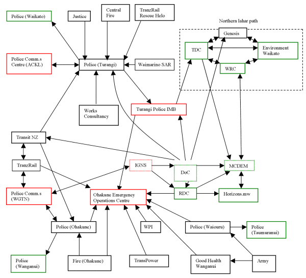
Figure 9. Organisational inter-relationships amongst involved agencies.
Communications Issues Between Organisations and Within Organisations
One of the major requirements for an effective disaster response is a set of clear and effective inter-organisational and intra-organisational information management and communications procedures. It is important to acknowledge that information management and communication are separate issues. The former is concerned with ensuring that the raw materials for decision making are available. The latter is concerned with the mechanisms by which it is transmitted. All to often, attention is given to communication, but not to ensuring that the data and information that is transmitted is of value to its recipient.
Inter-organisational communication includes communications between involved organisations that may not normally have any contact with one another. Even if they do, it is rarely in the demanding, stressful and complex operating environment likely to prevail during a crisis. The nature of these communication channels will differ between pre-event activities (planning etc.), activities during the event, and those post-event. At present some response groups have trouble communicating with each other because an integrated Civil Defence (CD) communications plan has not yet been finalised. Once this is finalised, and progress on information management is made (requiring systematic training in integrated and comprehensive emergency management), inter-organisational communications amongst response agencies will be greatly enhanced. Other plans may need to be devised to incorporate groups that normally sit outside the CD umbrella. Cooperative and collaborative work with such groups is required because they may have recovery responsibilities and/or be operating within a strategic context in regard to environmental sustainability etc..
The need to clarify and develop the lines of communication that exist within an organisation may often be overlooked. As highlighted above, within several organisations (such as Police, Fire, and DoC) this crosses functional boundaries. The complicated internal communications processes of these groups will affect their response. During disaster response activities these organisations are often operating under atypical conditions and pressures, so communications channels and procedures are therefore likely to differ from normal. Attempts to use standard modes of communication such as following existing hierarchical patterns (communicating with authority figures who may have little or no knowledge of a rapidly changing situation) rather than relying on the personnel on the spot can prove to be inefficient and even counter-productive.
Multi-organisation planning meetings have served to improve communications and coordination between relevant organisations. A communications group has also been set up to maintain and co-ordinate the flow of information during response planning. A Crater Lake Liaison meeting was held on September 4th, 2002, and attended by all interested parties. The Department of Conservation, Ruapehu District Council, the Ministry of Civil Defence and Emergency Management and Transit New Zealand all made presentations. The meeting provided an opportunity for discussion of response and communication issues, and the second meeting of the Lahar Communications Group (comprising RDC, TDC, DoC, Horizons.mw and MCDEM) immediately followed this.
Pager Activation and Response Issues
The benefits so far from the response development process can be seen in improvements made to the lahar alert procedures. Concerns with the original system are noted in the Taig Report (pp. 51-53). The system under development entails multiple signal paths to improve reliability. One path is to the Police Communications Centre; once staff at the Centre have been notified they will contact direct response staff to ensure that the pager message has been received (see Fig. 10). This reduces the possibility of breaking vital links in the communications chain. Work is continuing to resolve a number of technical issues.

Figure 10. ERLAWS warning transmission path. From RDC
emergency response plan.
This diagram is currently in ‘final draft’ form under review by
the Southern Ruapehu Lahar Planning Group.
The reliability of the pagers is an issue yet to be resolved, especially with regard to geographic areas where reception is unavailable. Tests need to be conducted to determine where these are (that is, where the pagers are non-functional) and a map of the affected areas produced.
The response plan is predicated on the smooth and continuous functioning of the technology so the above issues of ERLAWS and pager reliability are critical. DoC estimates ERLAWS will eventually achieve approximately 99.5% reliability, which equates to two days, or 44 hours, a year without a warning system. Performance monitoring reports whether ERLAWS is working and contingency plans are being developed if failure should occur at a critical time.
Lines of communication must be robust and contain redundancy and fall-back options. Systematic analyses of intra-organisation and inter-organisation information needs (an issue that is distinct from the analysis of communication) are needed to define problems, decision making capabilities and responsibilities, information sources, the nature of the information, interpretative requirements and collation requirements. Agencies (both scientific and technical) also need to undertake this process from the perspective of being information/data providers (including working with end-users to estimate the reliability and uncertainty inherent in the data they make available). All of these information needs will have to be transmitted along pre-arranged lines of communication. Organisations must also account for the possibility that during a Lahar emergency communication channels can be overloaded with unanticipated demands as, for example, media and civilians request information.
Some local organisations have expressed concern over how effectively the local telecommunications infrastructure will respond to the heavy demands placed on it during an event. It is difficult to quantify the level of demand that may arise once one includes the inevitable media and civilian traffic. During the 1995 eruption DoC, assisted by the Institute of Geological and Nuclear Sciences (GNS), had to cope with unexpectedly heavy demands from the media; reception staff numbers had to be boosted and an individual was brought in from DoC head office to act as a media liaison person.
In addition to the need for a comprehensive communications plan that includes the needs of the emergency response agencies, civilians’ requests and those of local and international media, responsibility for ensuring the integrity of the communication network and procedures needs to be assigned. One aspect of this is ensuring that adequate infrastructure is provided. The issue of unclear boundaries of functional authority also applies here. That is, whose role is it to provide this adequate infrastructure? Telecom? Whose responsibility is it to ensure that Telecom (for example) attend to this matter?
The Crater Lake problem provides MCDEM with a unique opportunity to test response systems and capabilities and to develop a training simulation and case study that can be used to illustrate and test emergency management capabilities in general.
Disaster Specific Training Needs
Some skills and competencies required to effectively manage and operate in a disaster response situation are unique and, in certain areas, may not conform to the standard practises of emergency response agencies. For example, command, control and communication procedures during a disaster event often differ from standard operating procedures and display less formality and greater flexibility and personal initiative. There is more reliance on the individual present at the event site to make significant decisions. Consequently, it is important that key response agencies develop appropriate operational response models that incorporate the skills, knowledge and competencies of all agencies likely to respond. Such response models underpin (a) the information and decision analyses required to facilitate response, (b) the development of distributed and naturalistic decision making procedures and (c) the levels of situational awareness required to manage complex emergencies (including those that may be evolving over time). For example, an organisation such as Fulton-Hogan may be required to undertake crowd and traffic management duties in ways which they may not be trained for. They must be capable of doing this in ways that are coordinated with the activities of organisations (e.g. police, Search and Rescue (SAR)) required to move people and vehicles through specific routes (e.g., movement of response personnel, evacuation). Front-line response personnel in disaster situations often become the target of stress and frustration from civilians angry at disruptions (which may occur on SH1 and SH49 in this case) or concerned with the fate of lost relatives etc.. Dealing with this in a stressful, uncertain environment requires training and self-control. Analyses must be undertaken of specific situations that may arise and what, if any, specific training will be required to handle those.
A lahar of this nature is a recurring event. Therefore attention must be paid to retaining the knowledge gained from the present situation to continue to provide an effective response in the future. A post-event analysis of training practices and procedures, as well as their subsequent effectiveness, will enable this process to be conducted more effectively the next time a lahar threat develops.
Training Program
Training needs analysis and training program and exercise development has so far been limited by the delays in the production of organisational response plans. Once response plans are fully developed and accepted then a program of training will begin. The exact nature and frequency of this regime has yet to be discussed in any depth but it will probably include:
To gain an acceptable level of proficiency it is envisaged that CIMS training, developing areas of specialist expertise, and simulation exercises will possibly have to be held initially once a month. No commitment to the required intensity of training has been made yet and it is likely that this commitment will be obtained only by gaining support at the highest levels within organisations, and the support of government.
It is unlikely that an effective standard of response proficiency will be obtained without conducting regular exercises, especially simulation exercises. Simulation exercises are vital in producing an effective response; especially considering the limited amount of time and resources available to train personnel. Simulation exercises will allow response personnel to experience the disaster response environment “for real” and put their skills into practise in a controlled and successful manner. Simulations can be critically evaluated and they provide feedback which facilitates the development of effective response and incident management. Simulations need to cover a variety of scenarios, the content of each designed to question pre-existing assumptions (which may reflect routine rather than disaster response behaviour) to determine how effective the plan is in most conceivable situations. Until simulation exercises are conducted, the effectiveness of the response plans cannot be gauged. Although a more costly option, developed simulation exercises will be a resource that can be used by MCDEM for future training needs more diverse than lahar hazard response alone.
Utilisation of Experiences Gained from Training
Exercises should be followed by a thorough debriefing that both determines the strengths and weaknesses of the performance and also gives personnel a realistic perception of their preparedness to meet the needs of a real event. The latter encourages a realistic level of expectation and helps prevent the potential build-up of a dangerous sense of over-confidence, in regard to both the individuals’ perception of their own abilities and the effectiveness of the plan overall. The notes from these sessions should be returned to organisations involved so the feedback gained can be used to implement improvements to their plans in an iterative process. Individual organisations’ employment of this feedback will most likely vary, with some organisations using it more effectively than others. This will be evident in following exercises which should act to motivate less proactive organisations to improve their performance.
Post event training may also be required in the form of support for disaster response workers, especially those that may have had to deal with casualties. While interventions such as compulsory psychological debriefing sessions are not recommended, the option for counselling support should be extended to all involved should it be required. Recent flooding crises have highlighted the substantial psychological toll that can be made on those in response roles. While the predictability of the crater lake event reduces the demands made on emergency managers, the possible need for prolonged response activities should be taken into account and highlights the need for stress inoculation and stress resilience training for emergency managers and other emergency responders. Dedicated emergency response agencies may already provide stress training and support services. Other organisations may need to implement it.. Stress resilience training is important to protect the well-being of personnel who may be required to deal with high levels of management demands and is also essential to facilitating effective response management, particularly in promoting effective decision making (and in terms of information management to furnish the necessary data for decision making).
Potential Impact of Personnel Shortfalls and Loss of Skills
Due to both the geographical location of the event and the nature of some of the response agencies, sometimes the full availability of allotted personnel cannot be guaranteed. For example, Police in smaller towns are of limited strength and may have to deal with other emergencies at the time of the event. Any response plan has to be flexible enough to compensate for this uncertainty and contain fallback or backup options. Acknowledgment of this issue can also serve to inform the plan development process in regard to assessing the likely effectiveness of a plan in the event of different (contingent) levels of resource availability. Organisations are attempting to incorporate these complexities into their plans. In the case of the Police it is envisaged that Fire personnel may take over their role until Police can relieve them. This increases the complexity of training needs. Not only do the primary response agencies need full training, but those that may be operating in a standby or backup capacity will have specific training needs as well. Note that the Police also plan to station extra personnel in the Ohakune area in a lahar emergency to mitigate some of their staffing shortfall.
Because of the window (likely a few years) before the event becomes imminent, trained staff may be reassigned as part of natural organisational or career development processes. Police personnel are especially mobile.
This effect has already impacted on the response development process. Three or four key personnel have already either left, or been reassigned within, organisations in the latter part of 2002. This is currently disruptive to the plan development process and may later impact on training and readiness for the event. In the longer-term, the relocation of trained personnel and loss of organisational memory will have a detrimental impact on using the knowledge gained from the upcoming incident to prepare for future emergencies.
Organisations need to develop proper succession planning protocols to ensure replacement personnel are effectively informed of the background to the situation, and made aware of the significance of this event. As trained staff are reassigned steps need to be taken to ensure that not only does their successor undertake the same formal training process, but also the informal knowledge and understanding of the situation be transferred, and efforts be made to rebuild the network of personal contacts established by their predecessor.
Training and education are ongoing processes, not a ‘one-off’ application. Ongoing training must accommodate (a) personnel newly involved with the situation, and (b) previously trained personnel, who will also need an ongoing reapplication and upgrading of skills to ensure an effective response to the lahar. Holding a couple of training exercises does not equate with long-term readiness and such a belief is not constructive but rather produces complacency, thereby increasing levels of real risk.
Fell, R. and Foster, M., 2003. Ruapehu Crater Lake tephra barrier failure modes and likelihood analysis (results of Crater Lake Scientific and Technical Advisory Panel (STAP) workshop). Unisearch Ltd. Report prepared for the Department of Conservation, New Zealand. 20p.
Goodwin, D., (Editor) 2001. ERLAWS - minutes of Design Review Meeting. Unpublished report, Enginuity Ltd and Department of Conservation, 16p.
Gledhill, K. and Scott, B.J., (compilers) 2001. Monitoring strategies that could be developed to deal with a Crater Lake dam-failure at Ruapehu volcano. Institute of Geological and Nuclear Sciences science report 2001/6. 22p.
Hancox, G.T., Hodgson, K.A. and Nairn, I.A., 1995. Reassessment of lahar hazard in the upper Tongariro River. Institute of Geological and Nuclear Sciences Limited client report 43605B.
Hancox, G.T., Nairn, I.A., Otway, P.M., Webby, G., Perrin, N.D. and Keys, J.R., 1997. Stability assessment of Mt Ruapehu crater rim following the 1995-1996 eruptions. Institute of Geological and Nuclear Sciences Client report 43605B, Lower Hutt, 41p.
Hancox, G.T., Otway, P.M. and Webby, G., 1998. Possible effects of a lahar caused by future collapse of the tephra barrier formed at the Mt Ruapehu Crater Lake outlet by the 1995-1996 eruptions. Institute of Geological and Nuclear Sciences Client report 43711B, Lower Hutt, 38p.
Hancox, G.T., Keys, H.(J.R.) and Webby, M.G., 2001. Assessment and mitigation of dam-break lahar hazards from Mr Ruapehu Crater Lake following the 1995-96 eruptions. Proceedings of the Geotechnical Society 2001 Symposium, Christchurch, New Zealand.
Johnston, D.M., Houghton, B.F., Neall, V.E., Ronan, K.R. and Paton, D., 2000. Impacts of the 1945 and 1995-1996 Ruapehu eruptions, New Zealand; an example of increasing societal vulnerability. Geological Society of America Bulletin, 112: 720-726.
Keys, H., 2003. Update on the size, probability and timing of a predicted barrier break lahar from Crater Lake and downstream risks to structures. Crater Lake Scientific and Technical Advisory Panel (STAP). Unpublished report, Department of Conservation, Turangi, 6p.
Leonard, G.S., Johnston, D.M. and Paton, D., 2004. Mitigating the lahar risk at Whakapapa Ski Area, Mt Ruapehu: Public perceptions and the effectiveness of the new warning system. Science Report 2004/(submitted), Institute of Geological and Nuclear Sciences, Lower Hutt.
Martin, R., Paton, D. and Johnston, D., 1999. Exercise Report: Civil Defence Exercise 1999 Poseidon’s Revenge, Environment Bay of Plenty Resource Planning Publication 99/05, Whakatane, 18p.
Neall, V.E., 2000. Independent scientific review of Department of Conservation's Assessment of Environmental Effects report entitled ‘Environmental and risk assessment for mitigation of the hazard from Ruapehu Crater Lake’. Institute of Natural Resources, Massey University. Unpublished report prepared for Minister of Conservation. 19p.
Scott, B.J., Houghton, B.F., Wilson, C.J.N., 1995. Surveillance of New Zealand’s volcanoes. Tephra, 14: 12-17.
Taig, T., 2002. Ruapehu Lahar Residual Risk Assessment. TTAC Limited Report N19. 83p.
|
|
|
|---|---|
|
Ambulance
|
|
|
Army
|
|
|
Department of Conservation
|
|
|
Environment Waikato
|
|
|
Fire, Ohakune
|
|
|
Fire, Raetihi
|
Provide back up for Fire, Ohakune. |
|
Fire, Waiouru
|
Provide staffing for roadblocks in support of the Police. |
|
Fire, Whakapapa
|
Provide staffing as required. |
|
Genesis Energy
|
|
|
Good Health Wanganui
|
|
|
horizons.mw
|
|
|
Lines Company
|
|
|
Institute of Geological and Nuclear Sciences
|
|
|
Mt Ruapehu Skifields
|
|
|
Opus International Consultants
|
|
|
Police, Ohakune
|
|
|
Police, Turangi
|
|
|
Rangitikei District Council
|
|
|
Ruapehu District council
|
|
|
Search and Rescue, Waimarino
|
|
|
Southern Ruapehu Emergency Management Committee
|
|
|
Taupo District Council
|
|
|
Transit NZ
|
|
|
Transpower
|
|
|
Tranzrail
|
|
|
Victim Support, Waimarino
|
|
|
Wanganui District Council
|
|
|
Winstone Pulp International
|
|
Table 1. Organisations involved in Crater Lake response and their individual
responsibilities.
From RDC Emergency Response Plan.
It was recognised that this understanding would improve as the lake filled and further investigative work was completed. The required response times were only indicative. This system was incorporated into both the southern and northern emergency management plans.
As a result of further investigation of the hard rock rim buried under the tephra dam, lake fullness (expressed as a %) is now based on the post-1995 level of the hard rock rim of the Crater Lake at the outlet. The square brackets have been removed and lake fullness values finalised.
- 100% indicates that the lake level is at the base of the tephra dam
- 117% indicates that the lake level is at the top of the tephra dam
Alert levels are linked to critical lake levels. These levels are now more accurately based on historical records of previous lahars, the damage they have caused, their magnitude, and relative travel times. Also included is the estimated relative probability of the lahar occurring at each level.
|
a) Level of Readiness
|
b) Lake Level
c) (msl) |
d) % | e) Explanation | f) Actions | g) Indicative Time for Lake to rise to next Alert Level in summer |
|
Normal
|
Below 2527 m. | <95 | Base level of readiness as per normal civil defence planning. | Planning, preparation, and training. | |
|
Level 1
|
2526.5 m. | 95 | Critical trigger point, 3 metres below the new rock overflow level. Waves caused by eruptions and small landslides could overtop barrier but the probability of a small collapse lahar caused by a resulting barrier failure is extremely low. | Planning
completed. Full response capability available and ready. Response within 30 minutes. |
|
|
Level 1b.
|
2529.5 m. | 100 | Lake full to the buried rock rim outlet level and the base of the tephra dam. Probability of barrier failure at this level is still very low. | 1 to 6 months to fill from Alert Level 1b to 2 | |
|
h) Level 2
|
i) 2533 | j) 108 | k) Sudden
collapse could produce a lahar equivalent to the 1975 event. This is
the largest historic lahar that has passed under the Tangiwai bridges (without
causing damage) and down the Tongariro River l) m) Conditional probability of barrier failure at this level is 1-2% |
n) Response within 20 minutes |
o) 0.7 to 1.9 months to fill from Level 2 to 3, or 7.8 months to drop down to Level 2 from Level 3, depending on infill rates. This large variation is due to the possibility of the filling spanning fast and slow filling rates, and seepage. Slow fill rates will probably result in net drops in lake level above about 2532m |
|
Level 3
|
2535 | 113 | Equivalent to a large moderately fast lahar Conditional probability of barrier failure at this level is 5-10% | Response within 10 minutes | 0.4 to 0.6 months to fill from level 3 to 3b, or 3.2 months to drop down to level 3 from 3b. |
|
Level 3b
|
2536 | 115 | Conditional probability is 50-60% | 0.2 to 0.3 months to fill from level 3b to 4, or 1.1 months to drop down to level 3b from 4 | |
|
Level 4
|
2536.5 | 116 | Equivalent to a large, fast lahar. Conditional probability is 90% | Response within 5 minutes | 0.2 to 0.3 months to fill from level 4 to 5, or 0.7 months to drop down to level 4 from level 5 |
|
Level 5
|
2536.9 | 117 | Lake at top of the tephra dam. Conditional probability is 100% |
Table 2. Response Agency Alert Levels are related to
Crater Lake fill levels
(current as of September 1st, 2003)
Response organisations will use this graduated system of alert levels to manage their own response planning and degrees of preparedness (refer Table 3 for a selection of example organisations and readiness actions).
|
|
ALERT LEVEL 1 | ALERT LEVEL 2 | ALERT LEVEL 3 | ALERT LEVEL 4 |
|
RESPONSE TIME
|
30 MINUTES | 20 MINUTES | 10 MINUTES | 5 MINUTES |
|
AGENCY
|
||||
|
OHAKUNE POLICE
|
Helicopter available
for aerial surveillance to be at the Waikato Stream on SH 1 within 40
minutes No-Fly Zone procedures completed (refer Appendix 6) Trained staff available to respond within 30 minutes |
Helicopter available
for aerial surveillance to be at the Waikato Stream on SH 1 within 40
minutes Provide all staff with pagers Trained staff available to respond within 20 minutes |
Helicopter available
for aerial surveillance to be at the Waikato Stream on SH1 within 30
minutes Provide all staff with pagers Install a mobile radio repeater to improve radio communications Trained staff available to respond within 10 minutes |
Helicopter available
for aerial surveillance to be at the Waikato Stream on SH 1 within 30
minutes Trained staff available to respond within 5 minutes |
|
WAIOURU POLICE
|
Trained staff available to respond within 30 minutes | Trained staff available
to respond within 20 minutes Provide all staff with pagers |
Trained staff available
to respond within 10 minutes |
Trained staff available to respond within 5 minutes |
|
TURANGI POLICE
|
Procedures to close
SH 1 at Rangipo in place Trained staff available to respond within 30 minutes |
Provide all staff
with pagers Trained staff available to respond within 20 minutes |
Trained staff available to respond within 10 minutes | Trained staff available to respond within 5 minutes |
|
RDC
|
Emergency Management
Plan completed EOC prepared and available for immediate use Completed resident and affected parties phone list Staff trained to use the phone list Coordinate a training exercise Gates installed at the Tangiwai Memorial Site Customer service staff trained to handle public enquiries about the lahar Review plans for alert level 2 |
Appoint a Recovery
Manager Review plans for alert level 3 |
Tangiwai Memorial
site closed Trained staff available to respond within 10 minutes Coordinate a training exercise EOC made operational and ready for immediate use Install a temporary radio repeater to improve radio communications Clear the overflow channel at Strachan’s Bridge Investigate and clarify criteria for pre-declaring a civil defence emergency. Engineering inspection services arranged Review plans for alert level 4 |
Trained staff available to respond within 5 minutes |
|
DOC-Crater Lake monitoring (Onsite observations depending
on level sensors & weather)
|
1-3 weekly in summer
(1) 2-4 weekly in winter (1) Status reports issued within 3 days of visit Annual rim survey |
1-2 weekly in summer 1-4 weekly in winter Status reports issued within 2 days Annual rim survey (4) |
weekly in summer 1-2 weekly in winter Status reports issued within ½ day Rim survey(s) (4) |
< weekly in
summer < weekly in winter Status reports issued within 1 hour Rim survey(s) |
|
DOC- ERLAWS
|
98-99.9% operational
(2) links to Transit, Police Comms completed pagers distributed pager carrier training completed GNS duty scientist network operational Interpretation report completed 24/7 web support plan in place maintenance plan prepared response pagers tested monthly |
Contingency plan
completed for a lahar warning during major outages of ERLAWS ERLAWS tested weekly, including pagers Rain gauge data from Genesis added to ERLAWS, plus other stream sensors |
ERLAWS tested weekly Response pagers tested daily |
ERLAWS tested weekly Response pagers tested daily Observer system in place to provide backup for ERLAWS |
|
DOC-Emergency Response Plan
|
Emergency Response
Plan completed First exercise completed warning signs installed to schedule (3) |
Review response
plan for level 3 Participate in training exercises |
Review response
plan for level 4 Schedule staff for lahar readiness |
Schedule additional staff for lahar readiness
|
| DOC-Public Awareness |
DOC contribution to public awareness communication plan
completed
specific graphic aids completed |
Update plan as
required Issue public information to schedule etc as required |
Update plan as
required Issue public information as required |
Update plan as
required Issue public information as required |
|
MCDEM
|
Facilitate the
planning for the lahar Coordinate the response to the lahar and any training |
Co-ordinate the response to the lahar and any training | Co-ordinate the response to the lahar and any training | Coordinate the response to the lahar and any training |
DOC Footnotes:
1. “Summer” is defined here as approximately 1 November to 1 May (period of most significant lake rise)
2. 98-99.9% operational means at least one of the three DOC-ERLAWS sites is online 99.9 % of the time, at least two are simultaneously online 98.0% of the time and the paging system is operating at least 99% of the time (as shown by performance monitoring).
3. See warning sign schedule
4. Rim surveys may need to become more frequent if deformation increases (e.g. J peak or Stump saddle)
Table 3. Organisational readiness activities (selected key organisations).
Footnote: 1 Tephra is a
collective term for unconsolidated volcanic airfall material.
Footnote: 2 In 1945 Mt
Raupehu erupted and a barrier across the Crater Lake outlet was created. This
barrier failed on 24 th December 1953 resulting in a lahar which travelled
down the Whangaehu River. At Tangiwai the rail bridge was destroyed resulting
in a train falling into the swollen river with the loss of 151 lives.
| Comments to Trauma.Webmaster@massey.ac.nz Massey University, New Zealand URL: http://www.massey.ac.nz/~trauma/ |
Disclaimer
Last changed April 26,
2004 |